
Holmains


Enclosure (Period Unassigned)
Site Name Holmains
Classification Enclosure (Period Unassigned)
Canmore ID 259012
Site Number NY07NE 41
NGR NY 0831 7649
Datum OSGB36 - NGR
Permalink http://canmore.org.uk/site/259012


- Council Dumfries And Galloway
- Parish Dalton
- Former Region Dumfries And Galloway
- Former District Annandale And Eskdale
- Former County Dumfries-shire
NY07NE 41 0831 7649
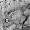
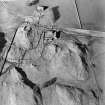
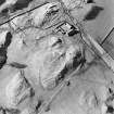
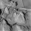
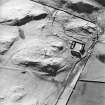
A circular enclosure, measuring about 35m in diameter, has been recorded on oblique aerial photography (RCAHMSAP 2002) on a knoll immediately SE of the site of Holmains tower (NY07NE 7). The enclosure is depicted on the 1st edition of the OS 6-inch map (Dumfriesshire 1861, sheet L).
Information from RCAHMS (KMM) 31 March 2004

