
Pricing Change
New pricing for orders of material from this site will come into place shortly. Charges for supply of digital images, digitisation on demand, prints and licensing will be altered.
Drumcoltran


Rig And Furrow (Medieval) - (Post Medieval)
Site Name Drumcoltran
Classification Rig And Furrow (Medieval) - (Post Medieval)
Canmore ID 258210
Site Number NX86NE 57
NGR NX 8699 6842
NGR Description Centred NX 8699 6842
Datum OSGB36 - NGR
Permalink http://canmore.org.uk/site/258210


- Council Dumfries And Galloway
- Parish Kirkgunzeon
- Former Region Dumfries And Galloway
- Former District Stewartry
- Former County Kirkcudbrightshire
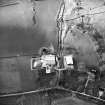
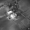
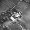
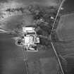
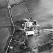
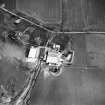
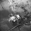
NX86NE 57 centred 8699 6842
An area of straight narrow rig has been recorded on oblique aerial photography (RCAHMSAP 2000) in the field immediately NE of Drumcoltran Tower. The rig is oriented roughly NNW-SSE.
Information from RCAHMS (KMM) 21 April 2004.

