
Following the launch of trove.scot in February 2025 we are now planning the retiral of some of our webservices. Canmore will be switched off on 24th June 2025. Information about the closure can be found on the HES website: Retiral of HES web services | Historic Environment Scotland
Middleton


Cottage (Period Unassigned), Farmstead (Period Unassigned)
Site Name Middleton
Classification Cottage (Period Unassigned), Farmstead (Period Unassigned)
Alternative Name(s) Unst, Croft At Castleton
Canmore ID 257695
Site Number HP60SW 65
NGR HP 62909 01223
Datum OSGB36 - NGR
Permalink http://canmore.org.uk/site/257695


- Council Shetland Islands
- Parish Unst
- Former Region Shetland Islands Area
- Former District Shetland
- Former County Shetland
HP60SW 65 62909 01223.
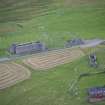
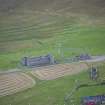
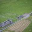
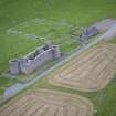
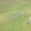
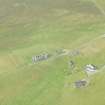
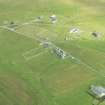
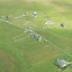
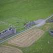
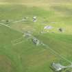
This site was visited as part of the RCAHMS Scottish Farm Buildings Survey. The farmstead comprises a single storey cottage plus a ruined outhouse. The building was roofed but derelict on the date of the visit.
Information from RCAHMS (ACD) 14 January 2008; NMRS MS 2560/330
Field Visit (29 April 2010)
A semi-derelict cottage is situated in improved pasture immediately N of the Clivocast to Muness public road. It measures about 10m from NE to SW by 5m transversely over clay-bonded, random rubble walls still standing to wallhead. The gables are capped with chimney stacks and the roof with its two skylights on the SE is intact although not weatherproof. A central doorway is flanked by single windows on the SE and there is a narrow front garden delimited by a wall. An unroofed gabled range abutting the rear of the cottage on the NW measures 17m from NE to SW by 3.8m transversely over random rubble walls which also stand to wallhead. The interior contains three compartments. There is an off-centred doorway in the SW gable which provides access to the most southerly compartment, while two doorways on the NW provide access to the others.
The cottage is depicted on the 1st edition of the OS 6-inch map with an outshot extending NW from the NE end of the building (Shetland 1882, sheet VIII), while the range is shown roofed on the 2nd edition of the map (Zetland 1902, sheet VIII).
Visited by RCAHMS (GLB) 29 April 2010.

