
Unst, Castleton Croft


Cottage (Period Unassigned), Farmstead (Period Unassigned)
Site Name Unst, Castleton Croft
Classification Cottage (Period Unassigned), Farmstead (Period Unassigned)
Canmore ID 257694
Site Number HP60SW 64
NGR HP 62954 01229
Datum OSGB36 - NGR
Permalink http://canmore.org.uk/site/257694


- Council Shetland Islands
- Parish Unst
- Former Region Shetland Islands Area
- Former District Shetland
- Former County Shetland
HP60SW 64 62954 01229.
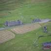
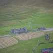
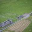
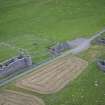
This site was visited as part of the RCAHMS Scottish Farm Buildings Survey. The farmstead comprises a single storey cottage plus a ruined outhouse. The building was roofed but derelict on the date of the visit.
Information from RCAHMS (ACD) 14 January 2008; NMRS MS 2560/330
Field Visit (29 April 2010)
This derelict cottage is situated in improved pasture 50m N of Muness Castle. It measures about 10.5m from NE to SW by 5m transversely over roughly coursed, clay-bonded rubble-and-slab walls standing to wallhead. The gables are capped with chimney stacks, but the roof with its two skylights on the SE is no longer weatherproof. There is a central doorway flanked by single windows on the SE. On the NW, there is a window offset to the SW and a central skylight in the roof. A gabled outshot to the NE stands to wallhead. This has a central doorway on the SE and another on the NW abutting the N corner of the cottage. The cottage is depicted roofed on the 1st edition of the OS 6-inch map (Shetland 1882, Sheet VIII).
Visited by RCAHMS (GLB) 29 April 2010.

