
Pricing Change
New pricing for orders of material from this site will come into place shortly. Charges for supply of digital images, digitisation on demand, prints and licensing will be altered.
South Ronaldsay, St Mary's Church, Churchyard


Burial Ground (Period Unassigned), Churchyard (Period Unassigned), Gate (Period Unassigned)
Site Name South Ronaldsay, St Mary's Church, Churchyard
Classification Burial Ground (Period Unassigned), Churchyard (Period Unassigned), Gate (Period Unassigned)
Canmore ID 256280
Site Number ND48SW 10.01
NGR ND 43992 84270
Datum OSGB36 - NGR
Permalink http://canmore.org.uk/site/256280


- Council Orkney Islands
- Parish South Ronaldsay
- Former Region Orkney Islands Area
- Former District Orkney
- Former County Orkney
ND48SW 10.01 43992 84270
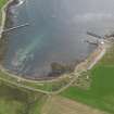
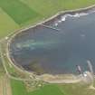
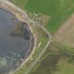
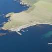
The churchyard is visible on oblique aerial views taken in 2008 (RCAHMSAP 2008), situated immediately E of the church and is generally rectangular in shape surrounded by a rubble stone wall, apart from an irregular length on the seaward side. There is a gabled gateway on the E side, which was added in 1830. There are a number of earlier gravestones within the kirkyard.
Information from RCAHMS (DE), February 2009.

