
Following the launch of trove.scot in February 2025 we are now planning the retiral of some of our webservices. Canmore will be switched off on 24th June 2025. Information about the closure can be found on the HES website: Retiral of HES web services | Historic Environment Scotland
Mains Of Huntingtower


Formal Garden (Period Unassigned)
Site Name Mains Of Huntingtower
Classification Formal Garden (Period Unassigned)
Canmore ID 256023
Site Number NO02NE 193
NGR NO 08177 25068
Datum OSGB36 - NGR
Permalink http://canmore.org.uk/site/256023


- Council Perth And Kinross
- Parish Tibbermore
- Former Region Tayside
- Former District Perth And Kinross
- Former County Perthshire
NO02NE 193 NO 08177 25068
NO02NE 193 0817 2507
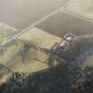
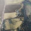
The slight earthworks of a formal garden, situated to the S of Mains of Huntingtower, were recorded during aerial survey in low sunlight (RCAHMSAP 2003). The site is rectangular on plan, measuring about 50m N and S by 35m E and W, and divided into regular sections. The garden is depicted as a rectangular enclosure on the 1st edition of the OS 6-inch map (Perthshire 1867, sheet lxxiii) with another parallel enclosure some 150m to the E. It is probable that the enclosures were part of the designed landscape related to the country house of Huntingtower (NO02NE1).
Information from RCAHMS (MMB) 1 December 2003
Watching Brief (October 2007 - March 2008)
A Cultural Heritage Assessment was undertaken by CFA Archaeology to identify the potential impact of the proposed Almond Valley Village Materplan development. The assessment included a desk-based study and field reconnaissance survey. The assessment considered the likely effects on cultural heritage interests arising from the development of the proposed new village near Almondbank
CFA Archaeology (G. Mudie, S. Hickman) 2008
OASIS ID - cfaarcha1-267801

