
Eigg, Struidh


Cave (Period Unassigned), Midden (Period Unknown), Platform (Prehistoric), Ritual Enclosure (Prehistoric)(Possible), Roundhouse (Prehistoric)(Possible), Hammerstone(S) (Period Unknown)
Site Name Eigg, Struidh
Classification Cave (Period Unassigned), Midden (Period Unknown), Platform (Prehistoric), Ritual Enclosure (Prehistoric)(Possible), Roundhouse (Prehistoric)(Possible), Hammerstone(S) (Period Unknown)
Alternative Name(s) Sron Na H-iolaire
Canmore ID 255803
Site Number NM48NE 58
NGR NM 49294 89897
Datum OSGB36 - NGR
Permalink http://canmore.org.uk/site/255803


- Council Highland
- Parish Small Isles
- Former Region Highland
- Former District Lochaber
- Former County Inverness-shire
Field Visit (6 May 2001)
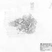
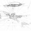
This unusual site is situated in the midst of a boulder field on the broken ground between the cliffs of Sron na h-Iolaire and the coast below. It consists of a substantial grass-and bracken-grown platform that measures about 20m from E to W by at least 10m transversely, on top of which there are the remains of a circular enclosure, probably a roundhouse, measuring about 6m in internal diameter within drystone rubble walls 2m thick. The wall thickens to 4m at the entrance to the enclosure where a narrow passage provides access to the interior. On the far side is the entrance to a large boulder cave that runs W beneath the enclosure wall. The main chamber of the cave measures about 7m from NE to SW by up to 3.5m transversely and 2.5m high; but there are other smaller chambers opening off to either side and at the end. The cave entrance and the sides of the chamber have been modified by the insertion of rough walling, while a thick deposit of midden material covers the floor. This includes animal bones, shells and broken hammerstones, some of which have a concretion of crushed shell to their points. Other hammerstones occur in the many small caves and voids found between and beneath the boulders nearby.
The site is unusual, but not unique for it has counterparts at Usinish on the east coast of South Uist where there are other roundhouses constructed around the entrance to boulder caves (NF83SW 4; NF83SW 6). What makes the Eigg site stand out is its position in the landscape. The cliffs on this side of the island are characterised by the horizontal banding of different lavas, but immediately above the site these bands are broken by a dramatic eruption of vertical basalt columns soaring to the top of the cliff. Standing in front of the roundhouse, the eye is immediately drawn upwards. The view is framed by two enormous boulders, one to each side and the sense that this has been an 'especial place' is inescapable. Hidden away in difficult terrain, access involves a tricky scramble over the boulder scree. The resources required to construct the platform and roundhouse suggest something of more importance than a farmhouse or a herdsman's hut. Little is known about religious practices in Western Scotland during the Iron Age, but it is tempting to speculate whether this might not be a prehistoric 'eremetic' site.
EIGG01 279
Visited by RCAHMS (SDB, MFTR) 6 May 2001
Measured Survey (4 September 2001)
RCAHMS surveyed the ritual enclosure at Struidh (Sron Na H-iolaire) on 4 September 2001 with plane-table and self-reducing alidade, producing a ground plan of the site at a scale of 1:500. The plan was redrawn in ink and later used as the basis of an illustration that was published in 2016 (Hunter, fig. 3.21).
Measured Survey (4 September 2001)
RCAHMS surveyed the underground structure at Struidh (Sron Na H-iolaire) on 4 September 2001 with plane table and alidade at a scale of 1:100. The plan was later used as the basis for an illustration published in 2016 (Hunter, fig. 3.21).

