
Bowhill, Gardens And Grounds


Garden (19th Century)
Site Name Bowhill, Gardens And Grounds
Classification Garden (19th Century)
Canmore ID 255519
Site Number NT42NW 16.04
NGR NT 42590 27740
NGR Description Centred NT 42590 27740
Datum OSGB36 - NGR
Permalink http://canmore.org.uk/site/255519


- Council Scottish Borders, The
- Parish Selkirk
- Former Region Borders
- Former District Ettrick And Lauderdale
- Former County Selkirkshire
Sbc Note
Visibility: This is an upstanding earthwork or monument.
Information from Scottish Borders Council
Sbc Note
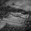
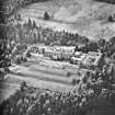
The designed landscape was laid out in the early 19th century and has remained similar in extent to the present day. It can be seen clearly on the 1stedition OS plan c.1860. Newark Castle, the original house, was considered as part of the designed landscape and was used in the 19th century as a 'folly' in the picturesque design. This extends from the north at Yarrowford to the south at Faulshape and is bordered by the two rivers. To the west the designed landscape is enclosed by woodland.
Information from Scottish Borders Council historic Environment Record
(n.d.)

