
Stonebyres, Quarry


Quarry (19th Century) - (20th Century)
Site Name Stonebyres, Quarry
Classification Quarry (19th Century) - (20th Century)
Canmore ID 255094
Site Number NS84SW 41
NGR NS 8352 4316
Datum OSGB36 - NGR
Permalink http://canmore.org.uk/site/255094


- Council South Lanarkshire
- Parish Lesmahagow
- Former Region Strathclyde
- Former District Clydesdale
- Former County Lanarkshire
Field Visit
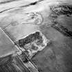
Large disused quarry, sun-rectangular in plan, 130m x 155m x 105m x 150m in extent, N-S, with vertical faces on N, E, & W sides and open to the south. There is evidence for a number of concrete bases that may have been used for structures or for machinery. Late 19th - early 20th century in date (not depicted on 1st Ed OS map)
Information from the Clyde and Avon Valley Landscape Partnership (Northlight Heritage), 2017

