
Pricing Change
New pricing for orders of material from this site will come into place shortly. Charges for supply of digital images, digitisation on demand, prints and licensing will be altered.
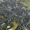
Crieff, Burrell Street, General


General View (Period Unassigned), Road (Period Unassigned)
Site Name Crieff, Burrell Street, General
Classification General View (Period Unassigned), Road (Period Unassigned)
Canmore ID 25483
Site Number NN82SE 6
NGR NN 861 215
NGR Description Centred NN 861 215
Datum OSGB36 - NGR
Permalink http://canmore.org.uk/site/25483


- Council Perth And Kinross
- Parish Crieff
- Former Region Tayside
- Former District Perth And Kinross
- Former County Perthshire
NN82SE 6 861 215.
A pavement of flagstones bedded closely together was found beneath the surface when the present road was being built through Burrell Street (NN 8595 2114 - 8619 2179), but the site is no longer known. This pavement is quoted as support for the tradition of a Roman Road that passed through the lands of Broich (NN 8620) and connected Strageath with Dalginross.
Name Book 1863; NSA 1845
No further information was found during field investigation.
Visited by OS (WDJ) 20 March 1963

