
Pricing Change
New pricing for orders of material from this site will come into place shortly. Charges for supply of digital images, digitisation on demand, prints and licensing will be altered.
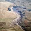
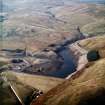
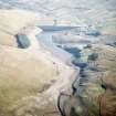
Upper Glendevon Reservoir And Dam


Dam (Period Unassigned), Reservoir (Period Unassigned)
Site Name Upper Glendevon Reservoir And Dam
Classification Dam (Period Unassigned), Reservoir (Period Unassigned)
Canmore ID 254823
Site Number NN90SW 62
NGR NN 9086 0454
NGR Description Centred NN 9086 0454
Datum OSGB36 - NGR
Permalink http://canmore.org.uk/site/254823
Ordnance Survey licence number AC0000807262. All rights reserved.
Canmore Disclaimer.
© Bluesky International Limited 2025. Public Sector Viewing Terms
- Correction
- Favourite

SC 1703080
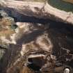
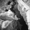
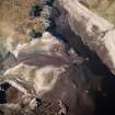
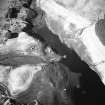
Oblique aerial view centred on the remains of sheepfolds and possible motte, taken during low water from the SSE.
RCAHMS Aerial Photography
16/10/2003
© Crown Copyright: HES

SC 1703082
Oblique aerial view centred on the remains of farmsteads, enclosures and sheepfold with quarry and sheep shelter adjacent, taken during low water from the SSE.
RCAHMS Aerial Photography
16/10/2003
© Crown Copyright: HES

SC 1111452
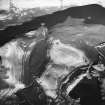
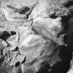
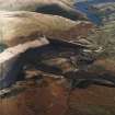
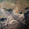
Digital copy of general oblique aerial view centred on the reservoir with quarry, farmsteads, enclosures, sheepfold and possible motte adjacent, taken during low water from the ESE.
RCAHMS Aerial Photography
16/10/2003
© Crown Copyright: HES

SC 1141484
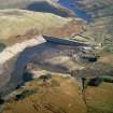
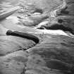
Oblique aerial view centred on the Upper Glendevon Reservoir dam with quarrying associated with its construction, farmsteads, sheepfold and enclosures adjacent, taken during low water from the WSW.
RCAHMS Aerial Photography
16/10/2003
© Crown Copyright: HES

SC 1703081
Oblique aerial view centred on the remains of farmsteads, enclosures and sheepfold with quarry and sheep shelter adjacent, taken during low water from the S.
RCAHMS Aerial Photography
16/10/2003
© Crown Copyright: HES

SC 1703102
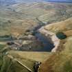
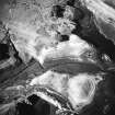
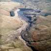
General oblique aerial view of the Lower Glendevon reservoir and dam with the Upper Glendevon reservoir beyond, taken from the ESE.
RCAHMS Aerial Photography
16/10/2003
© Crown Copyright: HES

SC 1703103
General oblique aerial view of the Lower Glendevon reservoir and dam with the Upper Glendevon reservoir beyond, taken from the E.
RCAHMS Aerial Photography
16/10/2003
© Crown Copyright: HES

SC 1703110
Oblique aerial view centred on the remains of the farmstead with another farmstead, sheepfold, enclosures and quarry adjacent, taken from the S.
RCAHMS Aerial Photography
16/10/2003
© Crown Copyright: HES

SC 1703279
General oblique aerial view centred on the reservoir with quarry, farmsteads, enclosures, sheepfold and possible motte adjacent, taken during low water from the WNW.
RCAHMS Aerial Photography
16/10/2003
© Crown Copyright: HES

SC 1703287
General oblique aerial view centred on the reservoir with quarry, farmsteads, enclosures, sheepfold and possible motte adjacent, taken during low water from the ESE.
RCAHMS Aerial Photography
16/10/2003
© Crown Copyright: HES

DP 222159
General oblique aerial view centred on Burnfoot Hill Windfarm, looking W.
RCAHMS Aerial Photography Digital
19/9/2015
© Crown Copyright: HES

SC 1703091
Oblique aerial view centred on the reservoir dam with quarrying associated with its construction, farmsteads, sheepfold and enclosures adjacent, taken during low water from the WSW.
RCAHMS Aerial Photography
16/10/2003
© Crown Copyright: HES

SC 1703105
Oblique aerial view centred on the remains of the farmstead and sheepfold with another farmstead and enclosures adjacent, taken during low water from the ESE.
RCAHMS Aerial Photography
16/10/2003
© Crown Copyright: HES

SC 1703286
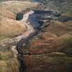
General oblique aerial view of the Upper Glendevon reservoir with the Lower Glendevon reservoir beyond, taken during low water from the WNW.
RCAHMS Aerial Photography
16/10/2003
© Crown Copyright: HES

SC 1703291
General oblique aerial view centred on the reservoir and dam, taken during low water from the E.
RCAHMS Aerial Photography
16/10/2003
© Crown Copyright: HES

SC 1703293
General oblique aerial view centred on the reservoir and dam, taken during low water from the ENE.
RCAHMS Aerial Photography
16/10/2003
© Crown Copyright: HES

DP 222105
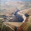
Oblique aerial view of Upper Glendevon Reservoir and dam, looking SSW.
RCAHMS Aerial Photography Digital
19/9/2015
© Crown Copyright: HES

DP 222157
General oblique aerial view centred on Burnfoot Hill Windfarm with Upper Glendevon Reservoir beyond, looking N.
RCAHMS Aerial Photography Digital
19/9/2015
© Crown Copyright: HES

SC 1703106
Oblique aerial view centred on the remains of the farmstead with another farmstead, sheepfold, sheep shelter, enclosures and quarry adjacent, taken from the ENE.
RCAHMS Aerial Photography
16/10/2003
© Crown Copyright: HES

SC 1703112
Oblique aerial view centred on the remains of the farmstead with another farmstead, sheepfold, sheep shelter, enclosures and quarry adjacent, taken from the E.
RCAHMS Aerial Photography
16/10/2003
© Crown Copyright: HES

SC 1703115
General oblique aerial view centred on the remains of the farmstead and sheepfold with another farmstead, enclosures and quarry adjacent, taken during low water levels from the NW.
RCAHMS Aerial Photography
16/10/2003
© Crown Copyright: HES

SC 1703276
General oblique aerial view centred on the reservoir with quarry, farmsteads, enclosures, sheepfold and possible motte adjacent, taken during low water from the W.
RCAHMS Aerial Photography
16/10/2003
© Crown Copyright: HES

SC 1703288
Oblique aerial view centred on the reservoir dam with quarrying associated with its construction, farmsteads, sheepfold and enclosures adjacent, taken during low water from the WSW.
RCAHMS Aerial Photography
16/10/2003
© Crown Copyright: HES

DP 222106
Oblique aerial view of Upper Glendevon Reservoir and dam, looking SSW.
RCAHMS Aerial Photography Digital
19/9/2015
© Crown Copyright: HES

DP 222163
General oblique aerial view centred on Upper Glendevon Reservoir and dam, looking WNW.
RCAHMS Aerial Photography Digital
19/9/2015
© Crown Copyright: HES

SC 1703083
Oblique aerial view centred on the remains of farmsteads, enclosures and sheepfold with quarry and sheep shelter adjacent, taken during low water from the ESE.
RCAHMS Aerial Photography
16/10/2003
© Crown Copyright: HES

SC 1703114
General oblique aerial view centred on the remains of the farmstead and sheepfold with another farmstead, enclosures and quarry adjacent, taken during low water levels from the N.
RCAHMS Aerial Photography
16/10/2003
© Crown Copyright: HES

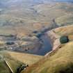
SC 1703273
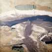
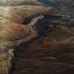
General oblique aerial view looking across the upper and lower reservoirs, taken from the W.
RCAHMS Aerial Photography
18/2/2003
© Crown Copyright: HES

SC 1703282
Oblique aerial view centred on the reservoir dam with quarrying associated with its construction, farmsteads, sheepfold and enclosures adjacent, taken during low water from the SE.
RCAHMS Aerial Photography
16/10/2003
© Crown Copyright: HES

SC 1703294
General oblique aerial view centred on the reservoir and dam, taken during low water from the ENE.
RCAHMS Aerial Photography
16/10/2003
© Crown Copyright: HES

SC 1780417
Oblique aerial view centred on the reservoir dam with quarrying associated with its construction, farmstead and enclosures adjacent, taken during low water from the SSW.
RCAHMS Aerial Photography
16/10/2003
© Crown Copyright: HES

SC 1141482
Oblique aerial view of Upper Glendevon Reservoir centred on the remains of farmsteads, enclosures and sheepfold with quarry and sheep shelter adjacent, taken during low water from the SSE.
RCAHMS Aerial Photography
16/10/2003
© Crown Copyright: HES

SC 1141483
General oblique aerial view centred on the Upper Glendevon Reservoir with quarry, farmsteads, enclosures, sheepfold and possible motte adjacent, taken during low water from the E.
RCAHMS Aerial Photography
16/10/2003
© Crown Copyright: HES

DP 222156
General oblique aerial view centred on Burnfoot Hill Windfarm with Upper Glendevon Reservoir beyond, looking N.
RCAHMS Aerial Photography Digital
19/9/2015
© Crown Copyright: HES

DP 222162
General oblique aerial view centred on Upper Glendevon Reservoir and dam, looking WNW.
RCAHMS Aerial Photography Digital
19/9/2015
© Crown Copyright: HES

SC 1703085
Oblique aerial view centred on the remains of farmsteads, enclosures and sheepfold with quarry and sheep shelter adjacent, taken during low water from the NNE.
RCAHMS Aerial Photography
16/10/2003
© Crown Copyright: HES

SC 1703101
General oblique aerial view of the Lower Glendevon reservoir and dam with the Upper Glendevon reservoir beyond, taken from the SE.
RCAHMS Aerial Photography
16/10/2003
© Crown Copyright: HES

SC 1703113
Oblique aerial view centred on the remains of farmsteads, enclosures and sheepfold with quarry and sheep shelter adjacent, taken during low water from the E.
RCAHMS Aerial Photography
16/10/2003
© Crown Copyright: HES

SC 1703277
General oblique aerial view centred on the reservoir with quarry, farmsteads, enclosures, sheepfold and possible motte adjacent, taken during low water from the W.
RCAHMS Aerial Photography
16/10/2003
© Crown Copyright: HES

SC 1703278
General oblique aerial view centred on the reservoir with quarry, farmsteads, enclosures, sheepfold and possible motte adjacent, taken during low water from the WNW.
RCAHMS Aerial Photography
16/10/2003
© Crown Copyright: HES

SC 1703281
Oblique aerial view centred on the reservoir dam with quarrying associated with its construction, farmstead and enclosures adjacent, taken during low water from the SSW.
RCAHMS Aerial Photography
16/10/2003
© Crown Copyright: HES

SC 1703292
General oblique aerial view centred on the reservoir and dam, taken during low water from the ESE.
RCAHMS Aerial Photography
16/10/2003
© Crown Copyright: HES

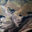
DP 222113
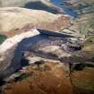
Oblique aerial view of Upper Glendevon Reservoir overflow and spillway, looking NW.
RCAHMS Aerial Photography Digital
19/9/2015
© Crown Copyright: HES

SC 1703084
Oblique aerial view centred on the remains of farmsteads, enclosures and sheepfold with quarry and sheep shelter adjacent, taken during low water from the NE.
RCAHMS Aerial Photography
16/10/2003
© Crown Copyright: HES

SC 1703111
Oblique aerial view centred on the remains of the farmstead and enclosures with quarrying and sheep shelter adjacent, taken during low water from the SSE.
RCAHMS Aerial Photography
16/10/2003
© Crown Copyright: HES

SC 1703283
General oblique aerial view centred on the reservoir with sheepfold and possible motte adjacent, taken during low water from the WNW.
RCAHMS Aerial Photography
16/10/2003
© Crown Copyright: HES

SC 1703284
General oblique aerial view of the Upper Glendevon reservoir with the Lower Glendevon reservoir beyond, taken during low water from the W.
RCAHMS Aerial Photography
16/10/2003
© Crown Copyright: HES

DP 222155
General oblique aerial view centred on Burnfoot Hill Windfarm with Upper Glendevon Reservoir beyond, looking NNE.
RCAHMS Aerial Photography Digital
19/9/2015
© Crown Copyright: HES

DP 222158
General oblique aerial view centred on Burnfoot Hill Windfarm with Upper Glendevon Reservoir beyond, looking NNW.
RCAHMS Aerial Photography Digital
19/9/2015
© Crown Copyright: HES

DP 229049
Oblique aerial view of the farmstead, field system and rig at Upper Glendevon Reservoir, looking W.
Historic Environment Scotland
15/1/2016
© Copyright: HES

SC 1703086
General oblique aerial view centred on the reservoir with quarry, farmsteads, enclosures, sheepfold and possible motte adjacent, taken during low water from the E.
RCAHMS Aerial Photography
16/10/2003
© Crown Copyright: HES

SC 1703274
General oblique aerial view looking across the upper and lower reservoirs, taken from the W.
RCAHMS Aerial Photography
18/2/2003
© Crown Copyright: HES

SC 1703275
General oblique aerial view centred on the reservoir with quarry, farmsteads, enclosures and sheepfold adjacent, taken during low water from the WSW.
RCAHMS Aerial Photography
16/10/2003
© Crown Copyright: HES

SC 1703285
General oblique aerial view of the Upper Glendevon reservoir with the Lower Glendevon reservoir beyond, taken during low water from the W.
RCAHMS Aerial Photography
16/10/2003
© Crown Copyright: HES


- Council Perth And Kinross
- Parish Tillicoultry (Perth And Kinross)
- Former Region Tayside
- Former District Perth And Kinross
- Former County Clackmannanshire
NN90SW 62 centred 9086 0454

