
Glencally


Rig And Furrow (Medieval) - (Post Medieval)
Site Name Glencally
Classification Rig And Furrow (Medieval) - (Post Medieval)
Canmore ID 254421
Site Number NO36SE 33
NGR NO 3551 6335
Datum OSGB36 - NGR
Permalink http://canmore.org.uk/site/254421


- Council Angus
- Parish Cortachy And Clova
- Former Region Tayside
- Former District Angus
- Former County Angus
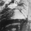
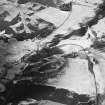
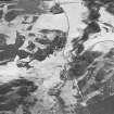
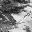
Aerial Photographic Interpretation (30 January 2004)
NO36SE 33 3551 6335
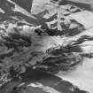
A large area of rig has been recorded by oblique aerial photography (RCAHMSAP 1999) within Glen Cally, to the SW and NW of Glencally farm.
Information from RCAHMS (KMM) 30 January 2004.

