|
Photographs and Off-line Digital Images |
E 94781 PO |
Records of Aberdeenshire Archaeology Service, Aberdeen, Scotland |
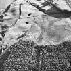
Oblique aerial view. |
30/5/2000 |
Item Level |
|
|
Photographs and Off-line Digital Images |
E 94782 PO |
Records of Aberdeenshire Archaeology Service, Aberdeen, Scotland |
Oblique aerial view. |
30/5/2000 |
Item Level |
|
|
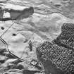
Photographs and Off-line Digital Images |
D 40111 |
RCAHMS Aerial Photography |
Oblique aerial view centred on the remains of a ring ditch house and three farmsteads with possible hut circle, buildings, farmsteads, hut circle and farmsteading adjacent, taken from the NE. |
16/11/1998 |
Item Level |
|
|
Photographs and Off-line Digital Images |
D 40112 |
RCAHMS Aerial Photography |
Oblique aerial view centred on the remains of a hut circle with three farmsteads, ring ditch house and farmsteading adjacent, taken from the NNE. |
16/11/1998 |
Item Level |
|
|
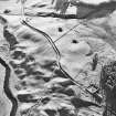
Photographs and Off-line Digital Images |
D 40113 |
RCAHMS Aerial Photography |
Oblique aerial view centred on the remains of three farmsteads with ring ditch house, possible hut circle, buildings, farmstead and farmsteading adjacent, taken from the NNE. |
16/11/1998 |
Item Level |
|
|
Photographs and Off-line Digital Images |
D 40114 |
RCAHMS Aerial Photography |
Oblique aerial view centred on the remains of a hut circle with three farmsteads and ring ditch house adjacent, taken from the NNW. |
16/11/1998 |
Item Level |
|
|
Photographs and Off-line Digital Images |
D 40115 |
RCAHMS Aerial Photography |
Oblique aerial view centred on the remains of three farmsteads with ring ditch house, hut circle and farmsteading adjacent, taken from the NNW. |
16/11/1998 |
Item Level |
|
|
Photographs and Off-line Digital Images |
D 40116 |
RCAHMS Aerial Photography |
Oblique aerial view centred on the remains of a farmstead with farmsteads, farmsteading, possible hut circle, buildings and banks adjacent, taken from the NNW. |
16/11/1998 |
Item Level |
|
|
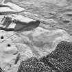
Photographs and Off-line Digital Images |
D 40122 |
RCAHMS Aerial Photography |
Oblique aerial view centred on the remains of three farmsteads with ring ditch house, possible hut circle, buildings, farmstead and farmsteading adjacent, taken from the S. |
16/11/1998 |
Item Level |
|
|
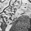
Photographs and Off-line Digital Images |
D 43360 CN |
RCAHMS Aerial Photography |
Oblique aerial view centred on the remains of ring-ditch houses, rig and small cairns with banks, rig, small cairn, farmsteads and buildings adjacent, taken from the E. |
8/2/1999 |
Item Level |
|
|
Digital Files (Non-image) |
DT 000030 |
Records of the Royal Commission on the Ancient and Historical Monuments of Scotland (RCAHMS), Edinbu |
RCAHMS Afforestable Land Survey: Glen Clova. Structures database. |
1999 |
Item Level |
|
 |
On-line Digital Images |
DP 067635 |
Scotland's Rural Past |
The Drums: view to S, with NE range in foreground |
10/2007 |
Item Level |
|
 |
On-line Digital Images |
DP 067636 |
Scotland's Rural Past |
The Drums: view S to corn drying kiln |
10/2007 |
Item Level |
|
 |
On-line Digital Images |
DP 067637 |
Scotland's Rural Past |
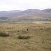
The Drums: NE range on left of shot, SE building and yard in centre |
10/2007 |
Item Level |
|
 |
On-line Digital Images |
DP 067638 |
Scotland's Rural Past |
The Drums: SW range looking W |
10/2007 |
Item Level |
|
 |
On-line Digital Images |
DP 067639 |
Scotland's Rural Past |
The Drums: plane table survey drawn at 1:200 |
21/7/2007 |
Item Level |
|
 |
On-line Digital Images |
DP 067640 |
Scotland's Rural Past |
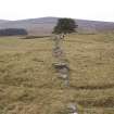
The Drums: dyke S of site |
10/2007 |
Item Level |
|
 |
On-line Digital Images |
DP 067641 |
Scotland's Rural Past |
The Drums: aerial photograph looking NE, with NE range and yard in foreground |
10/2007 |
Item Level |
|
 |
Digital Files (Non-image) |
WP 000295 |
Scotland's Rural Past |
The Timeline of Occupancy for Rochtaith/Rochteth, 1624-1861 |
9/2009 |
Item Level |
|
 |
On-line Digital Images |
SC 1716315 |
RCAHMS Aerial Photography |
Oblique aerial view centred on the remains of a ring ditch house and three farmsteads with possible hut circle, buildings, farmsteads, hut circle and farmsteading adjacent, taken from the NE. |
16/11/1998 |
Item Level |
|
 |
On-line Digital Images |
SC 1716316 |
RCAHMS Aerial Photography |
Oblique aerial view centred on the remains of a hut circle with three farmsteads, ring ditch house and farmsteading adjacent, taken from the NNE. |
16/11/1998 |
Item Level |
|
 |
On-line Digital Images |
SC 1716317 |
RCAHMS Aerial Photography |
Oblique aerial view centred on the remains of three farmsteads with ring ditch house, possible hut circle, buildings, farmstead and farmsteading adjacent, taken from the NNE. |
16/11/1998 |
Item Level |
|
 |
On-line Digital Images |
SC 1716318 |
RCAHMS Aerial Photography |
Oblique aerial view centred on the remains of a hut circle with three farmsteads and ring ditch house adjacent, taken from the NNW. |
16/11/1998 |
Item Level |
|
 |
On-line Digital Images |
SC 1716319 |
RCAHMS Aerial Photography |
Oblique aerial view centred on the remains of three farmsteads with ring ditch house, hut circle and farmsteading adjacent, taken from the NNW. |
16/11/1998 |
Item Level |
|


