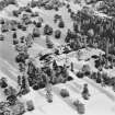
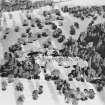
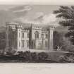
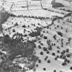
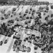
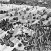
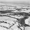
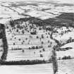
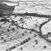
Accessibility

Font Size

100% 150% 200%

Background Colour

Default Contrast
Close Reset

Culdees Castle

Country House (19th Century)

Site Name Culdees Castle

Classification Country House (19th Century)

Alternative Name(s) Culdees Castle Policies

Canmore ID 25309

Site Number NN81NE 30

NGR NN 88492 16108

Datum OSGB36 - NGR

Permalink http://canmore.org.uk/site/25309

Ordnance Survey licence number AC0000807262. All rights reserved.
Canmore Disclaimer. © Bluesky International Limited 2025. Public Sector Viewing Terms

Toggle Aerial | View on large map

Digital Images

Culdees Castle and Policies, oblique aerial view, taken from the SSW.
Culdees Castle and Policies, oblique aerial view, taken from the SSW.Culdees Castle.
General view from North-East.Culdees Castle and Policies, oblique aerial view, taken from the S.Culdees Castle, NN81NE 30, Ordnance Survey index card, RectoCuldees Castle and Policies, oblique aerial view, taken from the WSW.Culdees Castle and Policies, oblique aerial view, taken from the SW.Engraving of Culdees Castle showing main front.
Titled: 'Culdees Castle, Perthshire. Drawn by J.P.Neale. Engraved by W. Wallis. Londoon Pub. May1st 1822 by J.P.Neale, 16 Bennett St., Blackfriars Road & Sherwood, Neely & Jones, Paternoster Row.'Culdees Castle and Policies, oblique aerial view, taken from the S.Culdees Castle and Policies, oblique aerial view, taken from the ENE, with the walled garden and stable block in the foreground.Muthill, Culdees Castle, interior
View of Drawing Room FireplaceCuldees Castle and Policies, oblique aerial view, taken from the S.Culdees Castle and Policies, oblique aerial view, taken from the SSE.Culdees Castle and Policies, oblique aerial view, taken from the SW.Muthill, Culdees Castle, interior
View of Dining Room FireplaceMuthill, Culdees Castle
Plan and elevation
Titled: 'Principal Floor Plan' 'South Elevation' 'North Elevation' 'Sketch Reconstruction of Original House'
Pencil on paperCuldees Castle.
General view from South-West.Culdees Castle and Policies, oblique aerial view, taken from the W.Culdees Castle Policies, oblique aerial view, taken from the NW.Culdees Castle and Policies, oblique aerial view, taken from the E, with the walled garden and stable block in the foreground.

Administrative Areas

  • Council Perth And Kinross
  • Parish Muthill
  • Former Region Tayside
  • Former District Perth And Kinross
  • Former County Perthshire

Archaeology Notes

NN81NE 30.00 88492 16108

NN81NE 30.01 NN 8883 1614 Stable Block

NN81NE 30.02 NN 8878 1607 Walled garden

NN81NE 30.03 NN 8867 1655 North Lodge

NN81NE 30.04 NN 8785 1623 Muthill Lodge

NN81NE 30.05 NN 8785 1564 South Lodge

Architecture Notes

NMRS REFERENCE:

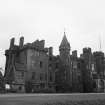
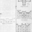
The original architect of Culdees Castle was James Gillespie Graham in 1810, but extensive additions were carried out by David Bryce in 1866 and are now held by RCAHMS

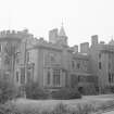
This Category C Listed building was demolished in 1967. Information from Demolitions catalogue held in RCAHMS library.

Site Management (18 June 1990)

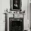
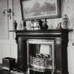
2-3 storey mansion with basement, built in red ashlar in the Gothic style. The mansion was baronialised and extended in 1867. The remodelling included the construction of a tower containing a family wing and chapel, and 2 new baronial towers to the rear.

Activities

Standing Building Recording (25 January 2022)

NN 88497 16109 A Basic level photographic and written survey was carried out, on 25 January 2022, on the East Wing of Culdees Castle in advance of the completion of its refurbishment as a wedding venue. A photographic and written survey was also carried out of the exterior of the remainder of the Castle coupled with a record of its now derelict interior using extant photographs and drawings.

Archive: NRHE

Funder: Culdees Castle Estate Ltd

Derek Hall

(Source: DES Volume 23)

OASIS ID: derekhal1-435668_

References

MyCanmore Image Contributions


Contribute an Image

MyCanmore Text Contributions