Accessibility

Font Size

100% 150% 200%

Background Colour

Default Contrast
Close Reset

Braco, Ardoch Old Bridge

Road Bridge (18th Century)

Site Name Braco, Ardoch Old Bridge

Classification Road Bridge (18th Century)

Alternative Name(s) Ardoch Bridge; River Knaik

Canmore ID 25263

Site Number NN80NW 7

NGR NN 83791 09914

Datum OSGB36 - NGR

Permalink http://canmore.org.uk/site/25263

Ordnance Survey licence number AC0000807262. All rights reserved.
Canmore Disclaimer. © Bluesky International Limited 2025. Public Sector Viewing Terms

Toggle Aerial | View on large map

Digital Images

Oblique aerial view centred on the remains of the Roman Fort, chapel and burial ground, with road bridge adjacent, taken from the NNW.
Oblique aerial view centred on the remains of the Roman Fort, chapel and burial ground, with road bridge adjacent, taken from the NNW.Oblique aerial view centred on the remains of the Roman Fort, chapel and burial ground, with road bridge adjacent, taken from the WNW.Oblique aerial view centred on the remains of the Roman Fort, chapel and burial ground, with Roman Temporary Camp and road bridge adjacent, taken from the SW.Oblique aerial view centred on the remains of the Roman Fort, chapel and burial ground, with Roman Temporary Camp and road bridge adjacent, taken from the SSW.Oblique aerial view of Ardoch Roman Fort, chapel, burial ground and adjacent road bridge, taken from the NNW.Oblique aerial view of the Roman fort at Ardoch, looking NE.Oblique aerial view of the Roman fort at Ardoch, looking NE.Oblique aerial view centred on the remains of the Roman Fort, chapel and burial ground, with road bridge adjacent, taken from the NE.Oblique aerial view centred on the remains of the Roman Fort, chapel and burial ground, with road bridge adjacent, taken from the WSW.Oblique aerial view centred on the remains of the Roman Fort, chapel and burial ground, with road bridge adjacent, taken from the ENE.Braco, Ardoch Old Bridge, NN80NW 7, Ordnance Survey index card, RectoBraco, Ardoch Old Bridge, NN80NW 7, Ordnance Survey index card, page number 1, RectoBraco, Ardoch Old Bridge, NN80NW 7, Ordnance Survey index card, page number 2, VersoOblique aerial view centred on the remains of the Roman Fort, chapel and burial ground, with road bridge adjacent, taken from the NW.Oblique aerial view centred on the remains of the Roman Fort, chapel and burial ground, with road bridge adjacent, taken from the NNE.Braco, Ardoch Old Bridge, NN80NW 7, Ordnance Survey index card, RectoOblique NNE aerial view of Ardoch Roman Fort, chapel, burial ground and adjacent road bridge.Oblique aerial view centred on the remains of the Roman Fort, chapel and burial ground, with road bridge adjacent, taken from the SE.

Administrative Areas

  • Council Perth And Kinross
  • Parish Ardoch
  • Former Region Tayside
  • Former District Perth And Kinross
  • Former County Perthshire

Archaeology Notes

NN80NW 7 83791 09914

(NN 8378 0991) Ardoch Bridge (NR) (Disused).

OS 6" map, (1958).

For successor and present bridge (at NN 83791 09902), see NN80NW 78.

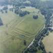
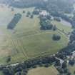
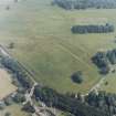
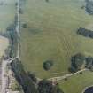
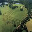
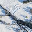
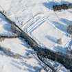
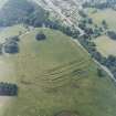
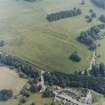
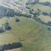
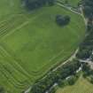
There are two bridges spanning the River Knaick within a few yards of each other, just below Ardoch Roman Fort. (NN80NW 10). The upper bridge, now disused, was erected in 1430 (said to be built by General Wade (Hunter 1897)). This original bridge was a single span only six feet wide, but an addition of three and a half feet seems to have been made to its width at some later time, but in 1896 this part fell into the stream. The building of the newer bridge was begun in 1861 and completed in 1862.

J Spottiswoode 1851; C Rogers 1853; Name Book 1863; T Hunter 1897; A H Anderson 1933.

The arch of the original is still standing. At its western end may be seen remains of the north parapet, abuttment and arch of the addition. It was probably restored or rebuilt when the military road from Stirling to Crieff was constructed, (1741-2).

Visited by OS (RD) 26 June 1967.

This bridge formerly carried a public road over the River Knaik to the NNE of the village of Braco.

Information from RCAHMS (RJCM), 29 May 2008.

References

MyCanmore Image Contributions


Contribute an Image

MyCanmore Text Contributions