
Pricing Change
New pricing for orders of material from this site will come into place shortly. Charges for supply of digital images, digitisation on demand, prints and licensing will be altered.
Barry Links, Barry Buddon Military Training Area


Tracked Target Range (19th Century) - (20th Century)
Site Name Barry Links, Barry Buddon Military Training Area
Classification Tracked Target Range (19th Century) - (20th Century)
Alternative Name(s) Green Braes
Canmore ID 252135
Site Number NO53SW 86
NGR NO 54047 32022
NGR Description Centred on NO 54047 32022
Datum OSGB36 - NGR
Permalink http://canmore.org.uk/site/252135


- Council Angus
- Parish Barry
- Former Region Tayside
- Former District Angus
- Former County Angus
NO53SW 86 centred on 54047 32022
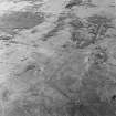
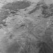
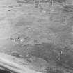
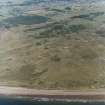
Centred on NO 54047 32022 are the remains of a complex of moving target ranges. Two tracks are aligned approximately N-S, while the third is aligned ENE-WSW. The easternmost track extends for about 600m, while the western track is about 450m long. Both ends of each track terminate in a loop. The ENE-WSW oriented trackway has a straight section of 600m, with a short (80-100m) northward spur at the eastern end; at the western end the track turns S and W to a target shed (at NO 5376 3178). A target shed remains, serving the Spion Kop ranges (NO53SW 85.01, NO53SW 85.02, NO53SW 85.03 ), but it is not known to what extent the original is incorporated.
This range is depicted on the current edition of the OS 1:10,000 map (1974).
Information from RCAHMS (DCC and GDT) 21 May 2004
Section of track noted where it crosses access road at NO 54167 32052. The track for the target range is visible on a RAF WW II vertical air photograph (D309, 4971, flown 26 June 1941). A shuttered concrete observation bunker stands at NO 53824 31835.
Visited by RCAHMS (DE), 10 August 2005

