Pricing Change
New pricing for orders of material from this site will come into place shortly. Charges for supply of digital images, digitisation on demand, prints and licensing will be altered.
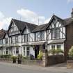
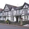
Bute, Rothesay, Minister's Brae, Elmlea
Terraced House (20th Century)
Site Name Bute, Rothesay, Minister's Brae, Elmlea
Classification Terraced House (20th Century)
Canmore ID 251974
Site Number NS06SE 291
NGR NS 08822 64271
Datum OSGB36 - NGR
Permalink http://canmore.org.uk/site/251974
- Council Argyll And Bute
- Parish Rothesay
- Former Region Strathclyde
- Former District Argyll And Bute
- Former County Buteshire
Characterisation (29 July 2010)
This site falls within the East Bay and Serpentine Area of Townscape Character which was defined as part of the Rothesay Urban Survey Project, 2010. The text below relates to the whole area.
Historical Development and Topography
Rothesay’s East Bay began to be developed as part of an early expansion of the town in the late 18th/early 19th century. As with much of Rothesay’s development, the layout of this area was dictated by the underlying topography, with development along the narrow coastal fringe stretching into Craigmore and beyond, and ultimately winding its way up the Serpentine Road towards Roseland.
Due to the nature of the area’s development, the East Bay and Serpentine Area of Townscape Character is linear in form as it stretches along East Princes Street and Battery Place. The southern portion consists of a planned terrace of mock half-timbered Edwardian Arts & Crafts style houses on Minister’s Brae designed by William Hunter and built c.1905, and the long terrace of Victorian villas at Crosshill Terrace in the south-eastern corner of the area. Around the Serpentine, plots are more random to fit around the steep hill and the winding road.
On its northern and southern edges, plots sizes are generally smaller and the density of these sections is higher than the central area around the Serpentine with its large detached villas in extensive garden plots.
There has been very little infilling in the area, apart from a pocket of mid-20th century local authority housing at St John’s Drive in the south-eastern corner of the area, a 1960s bungalow dwarfed amongst the 19th century tenements of Mountpleasant Road, and a handful of late 20th/early 21st century detached houses on the outer reaches of the Serpentine.
Present Character
This area of Rothesay takes much of its character from the layout of its road network. From the coastal Battery Place linking the town centre with Craigmore, to the narrow tenemented Mountpleasant Road, and the Serpentine twisting its way uphill to Common Hill. It is this road which distinguishes the area from elsewhere in Rothesay. Overall, there has been no change to the road layout around the area, and on the whole, there has been little infilling so plots remain as originally planned/developed.
The northern section of the area along Battery Place demonstrates the early 19th century development of Rothesay to accommodate visitors to the town, with a range of detached, semi-detached and terraced houses as well as some later 19th century four- and even five-storeyed tenements. Many of the latter are in typical Glasgow style being built from the same red sandstone found across Glasgow, where so many of the visitors to Rothesay in its heyday hailed from. Some also have the tiled ‘wally closes’ (communal stairwells) found in the city, along with decorative cast-iron balustrades and use of stained glass in internal vestibule doors. Most have large bay windows in the main rooms and have some degree of carved stonework whether shaped pediments above entrance doors or more intricate carving at eaves or on window surrounds.
One of the key features of the East Bay and Serpentine Area of Townscape Character, which is seen across Rothesay as a whole, particularly on those buildings beside or having views of the sea, is projecting bay windows and large windows to take full advantage of both the views and to bring as much light as possible into the buildings.
While most of the buildings throughout the East Bay and Serpentine Area of Townscape Character are fairly typical of their type and time, there is terrace of mock half-timbered Arts & Crafts style houses in Minister’s Brae (Ashlea, Rowanlea, Beechlea, Elmlea, and Oaklea), which are characteristic of their period but unusual for Rothesay. These were designed by local master builder William Hunter and built c.1905 along with the adjacent detached house, Marionslea, which was built c.1900 in the same style for William Hunter himself. This ‘English-style’ was typical of city suburbs and developing towns such as Gullane and North Berwick, and demonstrates the desire for their architects and those commissioning them to appear cosmopolitan and keeping up with the latest fashions in house design.
One of the key features of this area is the mostly original decorative Victorian lamp standards bearing the Rothesay coat of arms. These lamp posts are found along the seafront of the main part of Rothesay’s town centre, and are also found within the Town Centre Area of Townscape Character and West Bay Area of Townscape Character. In addition to these lamps, there is a smaller red lamp post in front of No 4 Battery Place. This is an example of a historic ‘Provost Light’. These lamps were erected in towns across Scotland to denote the residences of Provosts of Town Councils. A pair of lamps were placed on either side of the entrance to the Provost’s house, and remained in place as long as he held office. One light was removed once he retired and remained in place while he lived. This is a rare surviving example, though another exists outside No 25 Wyndham Road, in the Ardbeg Area of Townscape Character.
Information from RCAHMS (LK), 29th July 2010


