
Pricing Change
New pricing for orders of material from this site will come into place shortly. Charges for supply of digital images, digitisation on demand, prints and licensing will be altered.
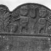
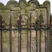
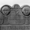
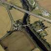
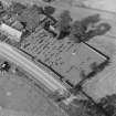
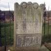
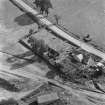
Pert Old Parish Church Graveyard


Burial Ground (Medieval)
Site Name Pert Old Parish Church Graveyard
Classification Burial Ground (Medieval)
Alternative Name(s) Church Of Pert; Pert Church
Canmore ID 251817
Site Number NO66NW 19.01
NGR NO 65008 66045
Datum OSGB36 - NGR
Permalink http://canmore.org.uk/site/251817


- Council Angus
- Parish Logie Pert
- Former Region Tayside
- Former District Angus
- Former County Angus
Note
Burial ground depicted on the 1st edition of the OS 25-inch map (1864). Extension depicted on the 3rd edition of the OS 25-inch map (1924).
Information provided by HES (C DeDeo) 9 April 2024

