
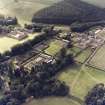
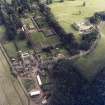
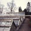
Manderston House, Walled Garden


Walled Garden (19th Century)
Site Name Manderston House, Walled Garden
Classification Walled Garden (19th Century)
Alternative Name(s) Manderston House Policies
Canmore ID 250692
Site Number NT85SW 24.16
NGR NT 80916 54694
Datum OSGB36 - NGR
Permalink http://canmore.org.uk/site/250692


- Council Scottish Borders, The
- Parish Duns
- Former Region Borders
- Former District Berwickshire
- Former County Berwickshire
NT85SW 24.16 80916 54694
Sbc Note (15 April 2016)
Visibility: Standing structure or monument.
Information from Scottish Borders Council

