 |
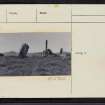
On-line Digital Images |
SC 2250919 |
Records of the Ordnance Survey, Southampton, Hampshire, England |
|
1975 |
Item Level |
|
 |
On-line Digital Images |
SC 2388981 |
Records of the Ordnance Survey, Southampton, Hampshire, England |
Acharn Falls, NN74SE 1, Ordnance Survey index card, Recto |
c. 1958 |
Item Level |
|
 |
On-line Digital Images |
SC 2388982 |
Records of the Ordnance Survey, Southampton, Hampshire, England |
Acharn Falls, NN74SE 1, Ordnance Survey index card, Recto |
c. 1958 |
Item Level |
|
 |
On-line Digital Images |
SC 2388983 |
Records of the Ordnance Survey, Southampton, Hampshire, England |
Acharn Falls, NN74SE 1, Ordnance Survey index card, page number 1, Recto |
c. 1958 |
Item Level |
|
 |
On-line Digital Images |
SC 2388984 |
Records of the Ordnance Survey, Southampton, Hampshire, England |
Acharn Falls, NN74SE 1, Ordnance Survey index card, page number 2, Verso |
c. 1958 |
Item Level |
|
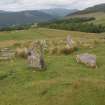 |
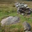
On-line Digital Images |
DP 496552 |
Historic Environment Scotland |
The ring from the SSW |
4/7/2023 |
Item Level |
|
 |
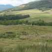
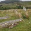
On-line Digital Images |
DP 496553 |
Historic Environment Scotland |
A view to the SW showing the shallow rectangular disturbance to the SW of the partly dismantled dyke in the foreground |
4/7/2023 |
Item Level |
|
 |
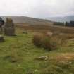
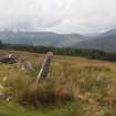
On-line Digital Images |
DP 496554 |
Historic Environment Scotland |
A distant view of the knoll with the stone circle upon its summit from the S |
5/7/2023 |
Item Level |
|
 |
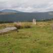
On-line Digital Images |
DP 496555 |
Historic Environment Scotland |
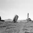
A view from the SE of the standing stone (4) and the stump (5) N of the grass-grown dyke |
4/7/2023 |
Item Level |
|
 |
On-line Digital Images |
DP 496556 |
Historic Environment Scotland |
A view from the SW of the two fallen stones (7, 6) on the NW side of the ring , with the stump and the standing stone to the N of the dyke (5, 4) in the background |
4/7/2023 |
Item Level |
|
 |
On-line Digital Images |
DP 496557 |
Historic Environment Scotland |
The inner face of the SW standing stone(1) |
4/7/2023 |
Item Level |
|
 |
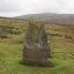
On-line Digital Images |
DP 496559 |
Historic Environment Scotland |
The NW standing stone (6) from the SE that lay partly under the dyke before being unearthed by the Rev. William Gillies in 1924 |
4/7/2023 |
Item Level |
|
 |
On-line Digital Images |
DP 496560 |
Historic Environment Scotland |
The standing stones on the S (2) and E side of the ring (3-4) |
4/7/2023 |
Item Level |
|


