
Acharn Falls


Stone Circle (Neolithic) - (Bronze Age)
Site Name Acharn Falls
Classification Stone Circle (Neolithic) - (Bronze Age)
Alternative Name(s) Auchlaicha, Aleckich, Greenland
Canmore ID 25004
Site Number NN74SE 1
NGR NN 76785 42492
Datum OSGB36 - NGR
Permalink http://canmore.org.uk/site/25004


- Council Perth And Kinross
- Parish Kenmore (Perth And Kinross)
- Former Region Tayside
- Former District Perth And Kinross
- Former County Perthshire
NN74SE 1 7678 4249.
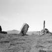
A stone circle consisting of seven stones, three fallen and four upright, lies in a fir plantation about a mile SE of Falls of Acharn. The site is crossed by a modern dyke which overlies one of the stones on the NW arc. (3) The maximum height of the upright sgtones is 5'8". Gillies "turned up" the centre of the circle, disclosing at a depth of 5" a black deposit 2' square by 5" deep which contained calcined bones.
W A Gillies 1925; J B Mackenzie 1909; F R Coles 1910
NN 7678 4249. A stone circle c.8.8m in diameter.
Surveyed at 1:10560.
Visited by OS (RD) 22 October 1970
No change from previous field report.
Surveyed at 1:10,000.
Visited by OS (JB) 29 September 1975
Field Visit (4 July 2023)
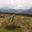
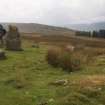
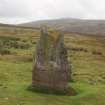
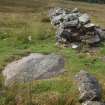
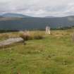
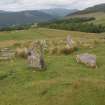
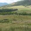
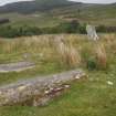
This stone circle is situated on a natural knoll at 365m OD, from where there is a fine outlook over Loch Tay that includes the range of mountains accompanying Ben Lawers to the W and Schiehallion to the N. The view to the S is more restricted, but the broken ground rises towards the summit of Creag an Sgliata. The ring of stones, which is sub-divided by a partly dismantled, grass-grown head dyke, crossing from E to NW, is circular on plan and measures roughly 9m in diameter. It now comprises seven stones of which four remain upright (1, 3-5) and three are prone - two having fallen outwards from the circumference of the ring (6-7) and one having fallen inwards (2). However, one of the uprights is only a stump (5), while two further stones may be missing on the SE and ENE respectively. The full complement would then have originally comprised nine stones, which may have been originally roughly spaced about 3m apart. It seems likely that they were consistently graded in height. The two tallest stones are situated on the SW and S sides of the ring (1: 1.6m in height; 2: 2.45m in length) – the latter once being the tallest, while the shortest is on the NE (4: 1.17m). Cattle poaching is especially marked around three of the stones (1- 3) and this has revealed packing stones around the foot of the only stone to remain vertical (1). There is a natural cup mark 0.3m above the ground level on its smooth, regular outer face. This contrasts strikingly with its inner face, which displays a protuberance close to its N edge and deep fissures over the remainder of its surface. Traces of turf-stripping disturb the uneven interior of the ring immediately SW of the dyke, the tumble from which largely obscures the ground immediately to its NE.
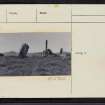
It is not known whether the Rev. Colin Macvean, the Minister of Kenmore, considered this ring when observing that ‘several Druidical temples have, in this parish survived, the waste of time’, but it plainly was one of those that largely escaped the more ‘destructive delapidations of the incurious and avaricious.’ Nevertheless, it was unknown to the Ordnance Survey, who surveyed the area in 1862 and again in 1898 (Perthshire 1867 and 1900, sheet LIX.10) showing only the head dyke passing through a large coniferous plantation. The ring was first described by the Rev. James Mackenzie (1909, fig. 2) at a time when his photograph shows that it was situated within a small clearing and only six stones were visible (1-5, 7). These were planned by the Edinburgh architect, John Macleod (ibid, fig. 2), which allowed him to establish that the ring had an inner diameter of 27ft 9ins (8.45m). It was replanned in 1910 by Frederick Coles (Coles 1910, 134, fig. 14), who also took a sketch from the E. This omitted the trees, but included the dyke and clearly shows its relationship to the stones. He identified their geology as a local schist and determined two to be missing, one on the NW (6) and the other on the SE; but his plotting was slightly awry, and two (3, 7) do not fit on the circumference of his reconstructed ring, which he estimated had a diameter of 30ft (9m). By contrast, the Rev. William Gillies paid several visits to the site in 1924 with Macleod’s plan in hand (Gillies 1925) and determined three stones to be missing from the broad gaps that the latter revealed. He located the prone orthostat on the NW (6) which partly lay under the dyke, but failed to find the others by probing on the E side of the ring. It seems likely that he was responsible for the wholesale removal of the late 18th-19th century dyke’s stonework in the gap adjacent to this stone, but whether he was responsible for its reduction to 0.3m in height where it crosses the rest of the the ring is unknown. Gillies also investigated the ring’s interior where he located a ‘dark deposit’ 2ft sq. (0.6m sq.) a few inches below the surface at its centre. This comprised charcoal mixed with calcined bones and was surrounded by reddish soil. The ring was plotted by the Ordnance Survey in 1970, while a photograph taken by a Field Investigator in 1975 indicates that the plantation had been felled (NN74SE 1). It also shows a small cairn within the ring’s interior, the material for which almost certainly must have derived from the dyke. John Barnatt recognised from the earlier reports that the orthostats had been graded in height, but believed the tallest lay on the SW (Barnatt 1989, vol. 2, 322). Aubrey Burl recognised this to have been the prone stone on the S (Burl 1995, 160-1). Burl may also have been correct in interpreting Gillies’ observations of the deposits within the centre of the ring as evidence of a funerary pyre that had been erected and ignited on the spot.
A search of the catalogue by Dr. Jess Thompson, the Curator of Osteology in the Department of Scottish History and Archaeology at the National Museums of Scotland, indicated that the cremated bone was not recorded as being in their collection.
Visited by HES Archaeological Survey (A. T. Welfare), 4 July 2023
Aubrey Jones, Taylor Wolf, Jessie Johnson and Lexie Thomas, students at the University of North Alabama (assisted by Professor George S. Mackowski), under the supervision of HES (Adam Welfare), surveyed Acharn Falls stone circle with plane-table and alidade on 4 July 2023 at a scale of 1:100. The resultant plan was redrawn in vector graphics software.

