
Pricing Change
New pricing for orders of material from this site will come into place shortly. Charges for supply of digital images, digitisation on demand, prints and licensing will be altered.
Upcoming Maintenance
Please be advised that this website will undergo scheduled maintenance on the following dates:
Thursday, 9 January: 11:00 AM - 3:00 PM
Thursday, 23 January: 11:00 AM - 3:00 PM
Thursday, 30 January: 11:00 AM - 3:00 PM
During these times, some functionality such as image purchasing may be temporarily unavailable. We apologise for any inconvenience this may cause.
Carn Na Marbh


Barrow (Prehistoric)(Possible)
Site Name Carn Na Marbh
Classification Barrow (Prehistoric)(Possible)
Alternative Name(s) Fortingall
Canmore ID 24996
Site Number NN74NW 4
NGR NN 7406 4693
Datum OSGB36 - NGR
Permalink http://canmore.org.uk/site/24996


- Council Perth And Kinross
- Parish Fortingall
- Former Region Tayside
- Former District Perth And Kinross
- Former County Perthshire
NN74NW 4 7406 4693
See also NN74NW 39.
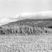
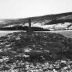
Below Kirkton village (Fortingall) is Carn na Marbh, the cairn of the dead. Plague victims were buried here by an old woman.
A Stewart 1928
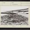
(NN 7386 4698) 'Here is a small tumulus with a stone on top. The stone bears a tablet with an inscription re-burial of plague victims in the 14th century'.
Information from M E C Stewart, 2 February 1956.
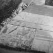
NN 7406 4693. Carn na Marbh (name verified) is a turf-covered mound of stones, c.12.0m N-S by c.8.5m and 1.1m high, situated on the edge of a river terrace in cultivated ground. It is surmounted by a vertical slab set in concrete, to which is attached the plaque stating the tradition of a plague burial. The mound appears to have been truncated on the E and W by ploughing, and enlarged by the addition of stone clearance, and it cannot be classified with certainty as a barrow or cairn.
Surveyed at 1:10,000.
Visited by OS (NKB) 2 October 1975
No change to previous field report.
Surveyed at 1:2500.
Visited by OS (MJF) 1 December 1978.
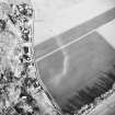
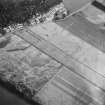
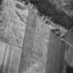
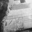
Magnetometry (27 September 2010 - 29 September 2010)
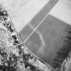
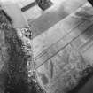
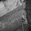
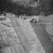
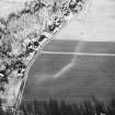
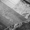
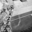
NN 74186 46970 A geophysical survey was undertaken 27–29 September 2010 in the vicinity of Fortingall village, as part of a project investigating the remains of early medieval monasteries in Perth and Kinross. A fluxgate-gradiometer survey was completed over the northern half of three fields
adjacent the village to the S and in a further field, known as the ‘glebe field’, immediately to the E side of the parish church. The survey was targeted to investigate the extent and interior of a possible early medieval monastic vallum, first identified through aerial photography in the 1980s. The results confirmed the extent of the main vallum ditch and discovered several internal enclosures interpreted as forming divisions of space within the monastery precinct. The interiors of several of these enclosures were associated with multiple prominent magnetic spikes, which may indicate early medieval industrial or occupation remains. To the W the Carn Na Marbh [NN74NW 4] was shown to be a possible enclosure by an extension of the vallum with an exterior entrance point. In the glebe field a clear break in the vallum ditch was interpreted as an eastern entrance point.
Archive: RCAHMS
Funder: Society of Antiquaries of Scotland

