Fortingall Church
Stone Setting(S) (Neolithic) - (Bronze Age)
Site Name Fortingall Church
Classification Stone Setting(S) (Neolithic) - (Bronze Age)
Canmore ID 24985
Site Number NN74NW 3
NGR NN 74541 46956
NGR Description NN 7451 4695, NN 7453 4697 and NN 7454 4692
Datum OSGB36 - NGR
Permalink http://canmore.org.uk/site/24985
- Council Perth And Kinross
- Parish Fortingall
- Former Region Tayside
- Former District Perth And Kinross
- Former County Perthshire
NN74NW 3 745 469.
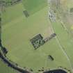
('A': NN 7451 4695) Standing Stones (NR) (3 groups of three shown)
('B': NN 7453 4697)
('C': NN 7454 4692)
OS 6" map (1901)
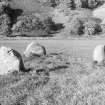
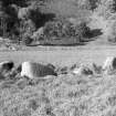
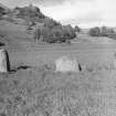
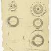
'A': Three remaining stones of a four-poster (information from H A W Burl letter, 24 November 1970) - smooth-sided, rounded and waterworn boulders 12' - 13' in girth but only 3'10" - 4'4" in height.
'B': Similar to 'A'. There was a trace of bone in the disturbed centre. 'C': Probably the remains of a recumbent stone circle, the three remaining stones being the recumbent stone 3'2" high, and its two flankers, 4' - 5' high.
Exploratory excavation by D Simpson in 1970 uncovered a stone hole 10' to the W, filled with small stones such as might come from a central cairn.
The occurrence of a double 4-poster such as that formed by 'A' and 'B' is apparently unique.
The stones are apparently of blue whinstone but obviously contain metal as compasses will not give a true reading in the area.
F R Coles 1908; H A W Burl 1972
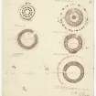
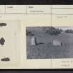
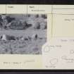
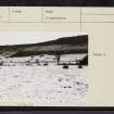
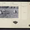
Three groups of stones (A -C) of which A and B are probably 4-posters. Group A comprises three standing stones as described and planned, the SW block being marginally the tallest. There is no trace of a cairn. Group B comprises four stones, of which the N and E are standing (0.8m and 1.0m high respectively), and the S block (the largest) is lying prone; a small block lying between the S and E stones is probably later clearance. There is no trace of a cairn.
The three standing stones of group C do not resemble a recumbent stone circle typified by the Aberdeenshire examples. They are in line (as planned by Coles), and therefore cannot be said to form part of a circle.
Surveyed at 1:10000.
Visited by OS (NKB) 2 October 1975
Before excavation in 1970, sites A and B seemed to be 4-posters from each of which one stone had been removed. Digging revealed that in reality they were sub-rectangular settings of eight stones with the largest stones at the corners. Flecks of charcoal and cremated bone were recovered. Both sides had had five stones deliberately overthrown and deeply buried, presumably in the 19th century, from the presence of a Victorian beer bottle under one stone. Whether the smaller stones had been added to two juxtaposed four posters is uncertain but paired eight stone circles are fairly common in central Scotland, and these settings may be the results of a mixing of traditions. C may be a ruined and idiosyncratic recumbent stone circle.
H A W Burl 1976
No change to previous field report.
Surveyed at 1:2500.
Visited by OS (MJF) 30 November 1978.
Scheduled as Fortingall Church, two stone circles and one stone row.
Information from Historic Scotland, scheduling document dated 14 February 2002.
Publication Account (1987)
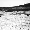
There are three settings of stones in the field, two of which were excavated in 1970. The first now comprises three uprights, but excavation revealed that there were originally eight set out in a rectangular arrangement with the largest stones at the corners. There are four stones of the second setting, but it too had originally comprised eight uprights. Charcoal and cremated bones survived from the prehistoric period but it is likely that the sites had been deliberately slighted in Victorian times, for a beer bottle was discovered under one of the toppled stones. The third setting consists of a massive boulder at the centre with two taller flanking stones, a layout that has been compared to that of the recumbent stone circles of Grampian.
On the flat river-terrace to the south-east of the village there is an unusual medieval earthwork of a class known as homestead moats (NN 734466); described on early editions of Ordnance Survey maps as Praetorium and thought of as part of a Roman camp, it, is in fact a rectangular moat with an inner and formerly an outer bank, within which there would originally have been timber buildings and perhaps a wooden stockade associated with the inner bank. The ditch is about 15 m broad and the central area is about 1.5 m above the level of the surrounding ground. There is an entrance causeway on the eastern flank of the moat.
Further to the west there is a mound with a cupmarked stone (NN 731465), and to the west near Bridge of Lyon (and visible from the road) there is what may be a neolithic long cairn (NN 729465); to the south-west of the moat there is a fine standing stone some 2 m high (NN 731464).
Information from ‘Exploring Scotland’s Heritage: Fife and Tayside’, (1987).
Publication Account (2011)
The southernmost of three stone settings on a terrace on the floor of the valley of the River Lyon 300m east south-east of Fortingall Church has been described as a ‘ruined and idiosyncratic recumbent stone circle’ (Burl 1976a, 194–5). The basis for this comparison lies in the composition of the setting. This lies north-west and south-east and comprises a pair of low pillars about 1.5m in height and standing 5.8m apart, apparently symmetrically flanking a lower boulder measuring 1.4m by 0.9m and no more than 1.2m in height. A trial excavation in 1970 was designed to test whether the setting stood on the south-west side of a circle and duly uncovered what has been interpreted as another stone-hole to the north-west (Burl 1988b, 175); the diameter of this postulated circle has been estimated variously at 23m (Thom et al 1980, 337) and 14.6m (Burl 1988b, 175; 1995, 160). Closer examination of the disposition of the three stones, however, suggests that they share little in common with the settings found at recumbent stone circles. Such settings consistently form a facade in which the flankers are typically placed hard against the recumbent and extend its long axis, even when turned slightly to pick up the arc of the circle. Here at Fortingall, what are supposed to be the flankers stand back from the recumbent, and both are turned at right-angles to the axis formed by the alignment of the setting as a whole. In effect, rather than forming a facade, they oppose each other like the corner stones of a four-poster. In this respect they replicate the design of the two settings to the north, which the excavations in 1970 demonstrated were essentially four-posters, but with lower intermediate stones in the centre of each side (Coles 1908, 121–5; Burl 1988b, 166–75). Furthermore, the alignment of the three stones roughly correlates with the alignment of both these monuments. In short, despite Burl’s protestations (1995, 160; 2000, 432, Per 27c), this setting is more likely to be the remains of a third four poster than any other form of circle (cf Barnatt 1989, 320–1, no. 7:30; Ruggles 1999, 188 no. 99, 266 note 27), and the discovery of the stone-hole to the north-west should perhaps be regarded as fortuitous until proven otherwise.


