
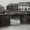
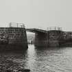
Dunbar, Old Harbour, Draw Bridge


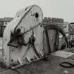
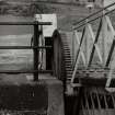
Bascule Bridge (19th Century)
Site Name Dunbar, Old Harbour, Draw Bridge
Classification Bascule Bridge (19th Century)
Alternative Name(s) Bascule Bridge; Victoria Harbour
Canmore ID 249714
Site Number NT67NE 424
NGR NT 68054 79291
Datum OSGB36 - NGR
Permalink http://canmore.org.uk/site/249714


- Council East Lothian
- Parish Dunbar
- Former Region Lothian
- Former District East Lothian
- Former County East Lothian
NT67NE 424 68056 79289
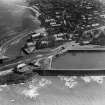
(Location cited as NT 680 793 and NT 681 792). Dunbar Harbour. The harbour is in two parts. The older section (c. 1710-30) consists of a basin formed by a curved rubble pier and a shorter straight pier. Some of the masonry is vertically set. A low wharf within the curved pier was for coal importation (1761).
The newer part - the Victoria Harbour (1842) - is formed by a sea wall linking two rock outcrops, together with a quay along the shore parallel with the wall. This section has two entrances, one to the old harbour channel, spanned by a hand-operated, wrought-iron, two-leaf bascule bridge; the other, at the N end, is open.
There is as 3-storey, 5-bay, harled store (Spott's Granary) on the old short pier.
J R Hume 1976.

