
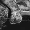
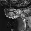
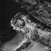
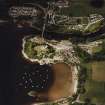
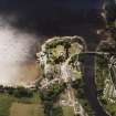
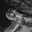
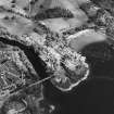
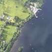
Loch Tay, Isle Of Spar


Crannog (Period Unassigned)
Site Name Loch Tay, Isle Of Spar
Classification Crannog (Period Unassigned)
Alternative Name(s) Spray Island; Spry Island; Spries Island; Spar Island
Canmore ID 24901
Site Number NN74NE 21
NGR NN 7730 4511
Datum OSGB36 - NGR
Permalink http://canmore.org.uk/site/24901


- Council Perth And Kinross
- Parish Kenmore (Perth And Kinross)
- Former Region Tayside
- Former District Perth And Kinross
- Former County Perthshire
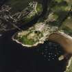
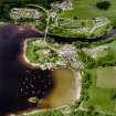
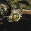
NN74NE 21 7730 4511.
This crannog is exposed to a height of about 3m above the normal level of the loch and has measured about 60m by 34m since it was re-built in 1842 prior to a visit by Queen Victoria; the trees and walling on the island appear to date from this period. The crannog is shown in Blaeu's Atlas and on a map of 1720. This is probably the 'small islet near the shore in the Bay of Kenmore' that Stuart mentions.
J Stuart 1868; F O Blundell 1913; W A Gillies 1938; G E Oakley 1973; T N Dixon 1983; I Morrison 1985
A summary of the work carried out by the Scottish Trust for Underwater Archaeology in 2004 is included in The University of Edinburgh's 50th Annual Report, 2004.
N Dixon 2004

