Accessibility

Font Size

100% 150% 200%

Background Colour

Default Contrast
Close Reset

Invernahavon

Battle Site (14th Century)

Site Name Invernahavon

Classification Battle Site (14th Century)

Canmore ID 24630

Site Number NN69NE 2

NGR NN 689 962

Datum OSGB36 - NGR

Permalink http://canmore.org.uk/site/24630

Ordnance Survey licence number AC0000807262. All rights reserved.
Canmore Disclaimer. © Bluesky International Limited 2025. Public Sector Viewing Terms

Toggle Aerial | View on large map

Digital Images

General oblique aerial view of the Invernahavon battlesite at the confluence of the Spey and Truim, looking SW.
General oblique aerial view of the Invernahavon battlesite at the confluence of the Spey and Truim, looking SW.General oblique aerial view of the Invernahavon battlesite at the confluence of the Spey and Truim, looking SW.General oblique aerial view of the Invernahavon battlesite at the confluence of the Spey and Truim, looking SW.Oblique aerial view of the pig farm at the Invernahavon battle site, looking WNW.Invernahavon, NN69NE 2, Ordnance Survey index card, RectoInvernahavon, NN69NE 2, Ordnance Survey index card, Recto

Administrative Areas

  • Council Highland
  • Parish Kingussie And Insh
  • Former Region Highland
  • Former District Badenoch And Strathspey
  • Former County Inverness-shire

Archaeology Notes

NN69NE 2 689 962.

(Name: NN 689 962) Site of Battle of Invernahavon (NR)

Fought AD. 1386

OS 6"map, Inverness, 2nd ed., (1903)

The scene of a clan battle between the MacKintoshes and Camerons, in the reign of James I, caused by the refusal of certain Camerons to pay their rents on property in Lochaber owned by the MacKintoshes.

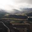
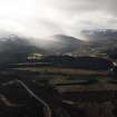
The site at Invernahavon is near the junction of the rivers Spey and Truim.

G Anderson 1834.

No further information.

Visited by OS (NK B) 28 September 1965.

References

MyCanmore Image Contributions


Contribute an Image

MyCanmore Text Contributions