Clach Na H-iobairte
Cairn (Period Unassigned), Standing Stone (Prehistoric)
Site Name Clach Na H-iobairte
Classification Cairn (Period Unassigned), Standing Stone (Prehistoric)
Canmore ID 24576
Site Number NN65NW 1
NGR NN 6171 5896
Datum OSGB36 - NGR
Permalink http://canmore.org.uk/site/24576
- Council Perth And Kinross
- Parish Fortingall
- Former Region Tayside
- Former District Perth And Kinross
- Former County Perthshire
NN65NW 1 6171 5896.
(NN 6171 5896) Clach na h-Iobairte (NR).
OS 6" map (1900)
This is a standing stone on top of a burial cairn (see near Lundin in Strathtay (NN85SE 20).
Information from M E C Stewart 20 November 1962.
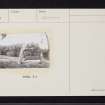
Clach na h-Iobairte ('the stone of the offering') is situated in the S quadrant of a stony mound on a low natural knoll overlooking Loch Rannoch. The mound is rather amorphous but appears to measure about 10.0m in diameter; it has stone clearance upon it, together with a large boulder embedded in the N side, and two stone blocks with drill holes lie on the E.
The standing stone, with its broad face roughly NE-SW and leaning to the SE, is unweathered. It measures 1.9m in height, 0.6m in width at the top, 0.3m at the base, and 0.2m thick. On its SE face there is what appears to be an incised inverted 'T'. See GP.
Name still known locally.
Surveyed at 1/2500.
Visited by OS (RD) 23 June 1969.


