
Lawers Burn


Enclosure(S) (Period Unassigned), Shieling Hut(S) (Post Medieval)
Site Name Lawers Burn
Classification Enclosure(S) (Period Unassigned), Shieling Hut(S) (Post Medieval)
Alternative Name(s) Meall Greigh
Canmore ID 24546
Site Number NN64SE 2
NGR NN 66271 42769
NGR Description Centred NN 6630 4280
Datum OSGB36 - NGR
Permalink http://canmore.org.uk/site/24546


- Council Perth And Kinross
- Parish Kenmore (Perth And Kinross)
- Former Region Tayside
- Former District Perth And Kinross
- Former County Perthshire
NN64SE 2 Centred 66271 42769.
Area centred NN 6623 4285. There are at least thirty-two shielings near the head of the Lawers Burn at a height of about 2000ft above sea-level, on a fairly level area of moorland cut through by several unnamed streams. They are of the earlier boat-shaped type, measuring about 7.0m x about 3.0m with stone walls "turfed-up" on the outside.
Visited by OS (WDJ) 27 August 1969.
Six unroofed shieling-huts are depicted on the 1st edition of the OS 6-inch map (Perthshire 1867, sheet lviii). Eleven unroofed shieling-huts are shown on the current edition of the OS 1:10000 map (1981).
Information from RCAHMS (AKK) 28 October 1997.
A second season of excavation and survey were undertaken at Meall Greigh as part of the Ben Lawers Historic Landscape Project (DES 2002, 93-4).
NN 6623 4285 Meall Greigh. Excavation and geophysical survey took place in a former shieling ground on the W-facing slopes of Meall Greigh near the head of the Lawers Burn. A rectangular shieling hut with linear mounds to either side of its entrance was investigated, along with the area immediately behind and including part of a stone dairy. A fire-spot and several layers of earth floor were found inside the hut, while outside it evidence was found for the use of turf to support its walls and for the dumping of midden material and rake-out. Several stone pot lids and sherds of 16th to 17th-century pottery were found. To the N of the shieling hut, excavation revealed another fire-spot, associated with carbonised hazelnut shell, which may pre-date the shieling structures.
Report to be lodged with Perth and Kinross SMR and the NMRS.
Sponsors: HS, HLF, SNH, NTS.
J A Atkinson, O Lelong, G MacGregor and K G McLellan 2003
Field Visit (18 April 2000)
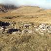
NN 66271 42769. This large group of structures, comprising over sixty shieling-huts and several small enclosures, extends for about 300m along a broad terrace above the N bank of the Lawers Burn. Many of the huts survive only in fragmentary condition, having been built over, robbed, or eroded by one of the three minor burns that dissect the terrace, while others survive only as low turf mounds. Thirty, however, are reasonably well defined, roughly rectangular on plan and measuring internally from 1.5m to 5.2m in length and from 1.2m to 2.4m in breadth. They can be divided into two types on the basis of their wall construction, seventeen huts having walls entirely or largely built of turf, and thirteen having an internal stone facing encased within an outer shell or embankment of turf. The turf-embanked type includes most of the largest huts (six of the eight that measure 4.4m or more in length), but it also includes some of the smallest, including two sub-circular huts that measure only 1.5m in internal diameter (BL00 34, 41). Fifteen huts (including most of the turf-embanked ones) have low mounds outside their entrances, probably representing accumulations of midden material, which in some cases appear as a pair of elongated banks flanking the approach to the hut doorway. Internal features include aumbries set into the walls, which are found in four turf-embanked huts (BL00 33, 38, 40, 47), and an edge-set slab in one turf hut (BL00 52), positioned to one side of the entrance, which is probably part of a hearth. Finally, scattered amongst the huts there are at least four small enclosures, the largest of which measures about 6m in diameter within a turf bank.
John Farquharson's 1772 Plan of Deshoir (National Archives of Scotland, RHP 569) is annotated 'Sheallings of Lawers' across the area occupied by these huts (and also across the area of the huts described under NN64SE 8), though the plan does not show any individual huts. The 1st edition of the OS 6-inch map (Perthshire 1867, sheet lviii) depicts six huts, all roofless, but it is not possible to identify these on the ground with any confidence.
(BL00 33-64)
Visited by RCAHMS (AGCH, DCC) 18 April 2000
Note (1 August 2007)
The excavations in 2003 centred on a shieling-hut at NN 66397 42744. Details are contained in a report published in 2004.
Information from RCAHMS (SDB) 1 August 2007.
J A Atkinson, O Lelong, G MacGregor and K G McLellan 2004 (RCAHMS MS 2058).

