
Meall Odhar


Peat Stand(S) (Period Unassigned)
Site Name Meall Odhar
Classification Peat Stand(S) (Period Unassigned)
Canmore ID 24542
Site Number NN64SE 14
NGR NN 66347 40417
Datum OSGB36 - NGR
Permalink http://canmore.org.uk/site/24542


- Council Perth And Kinross
- Parish Kenmore (Perth And Kinross)
- Former Region Tayside
- Former District Perth And Kinross
- Former County Perthshire
NN64SE 14 66347 40417
NN 664 404 Old Shielings. (NAT)
OS 1:10000 map (1981)
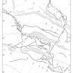
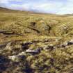
NN 66347 40417. This large group of peat stack stances is disposed along the braided course of a trackway climbing the hillside above the head-dyke of Ben Lawers Farm, to the NE of Meall Odhar. Fifty-two stances have been identified in an area measuring 400m from NW to SE by 200m transversely. Each stance comprises a roughly rectangular enclosure, defined by low rubble walls that are in most cases little more than lines of large stones. They measure internally from 1.3m to 12.2m in length and from 1m to 2.2m in breadth, though the vast majority are between 3.5m and 8.5m long and between 1.2m and 1.8m broad. Most of them have been built with their long axis across the contour, but only five show any signs of an attempt to level the interior, either by levelling up the lower end (BL00 1619, 1630, 1633) or by digging into the slope at the upper end (BL00 1629, 1643). In most cases one end has been left open, either that facing uphill or that facing directly onto the trackway. Four are now in a fragmentary condition and several have been damaged by the widening (possibly through natural erosion) of lengths of trackway. One (BL00 1612), however, has been built directly across the line of a trackway. At least four have been subdivided into two or more compartments (BL00 1620, 1644, 1647, 1650) and one has been built over the end of an earlier stance (BL00 1640-1). Finally, two stances retain remnants of peat stacks; in one case (BL00 1612) a roughly square mound of peat, measuring 1.5m across and 0.2m in height, blocks the open end of the stance, and in the other (BL00 1631), there is a low mound in the lower end of the stance.
A cluster of stances towards the N edge of this group was planned at 1:250 scale.
(BL00 1106, 1605, 1607-44, 1646-50, 1835, 1948-9)
Visited by RCAHMS (SDB) 20 September 2000 and 5 October 2000
Measured Survey (7 May 2003)
RCAHMS surveyed the peat stack stances at Meall Odhar on 7 May 2003 with plane-table and self-reducing alidade at a scale of 1:250.

