
Allt A' Choire Chireinich


Peat Cutting (Period Unassigned), Shieling Hut(S) (Post Medieval)
Site Name Allt A' Choire Chireinich
Classification Peat Cutting (Period Unassigned), Shieling Hut(S) (Post Medieval)
Alternative Name(s) Meall Odhar
Canmore ID 24538
Site Number NN64SE 10
NGR NN 65070 40100
Datum OSGB36 - NGR
Permalink http://canmore.org.uk/site/24538


- Council Perth And Kinross
- Parish Kenmore (Perth And Kinross)
- Former Region Tayside
- Former District Perth And Kinross
- Former County Perthshire
NN64SE 10 65070 40100
NN 650 401. A group of approximately six small rectangular structures, probably shielings, by a stream at about 625m OD.
Surveyed at 1:10,000.
Visited by OS (JRL) 12 December 1978
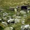
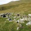
NN 65070 40100. Situated on a terrace above the E bank of the Allt a' Choire Chireinich, and NW of Meall Odhar, there is a group of at least eight shieling-huts. A ninth hut stands about 70m to the SE, and there are traces of further structures to the NW and WSW. There is also evidence of peat-cutting immediately to the W of the main group.
Three of the huts in the main group stand out by reason both of their larger size and their method of construction (BL00 95, 97-8). They are roughly rectangular, measuring from 5m to 5.4m in length and 1.7m to 2.2m in breadth internally. Their walls stand up to 0.9m in height, and comprise an internal stone facing encased within an outer shell or embankment of turf. They are all entered on the SE, and the approach to the entrance of each hut is flanked by a pair of turf banks, which may represent accumulations of midden material. Set into the floor of two of these huts (BL00 97-8), to one side of the doorway, there is an edge-set slab, probably the backstone of a hearth. Finally, two of the three (BL00 95, 98) have one or more aumbries set into their walls. The other six huts (including the outlier to the SE (BL00 203; NN 65129 40048)), are built wholly or largely of turf and measure internally up to 2.5m in length and 2.2m in breadth. Amongst the huts in the main group there are several amorphous mounds and short stretches of turf bank, which may represent the remains of earlier structures, and fragments of a possible tenth hut can be seen 30m to the NW at NN 65033 40131, while 50m WSW of the main group, at NN 65064 40102, there is a rectangular platform cut into the E side of the burn gully.
The ground between the huts and the gully is flat and boggy, and bears traces of shallow peat-cuttings. The cuttings appear to cut across a trackway that runs past the shieling-huts, following the line of the burn.
The main group of huts was planned at 1:250 scale, and a cross-section through one hut (BL00 98) was drawn at 1:50.
(BL00 93-99, 203, 259)
Visited by RCAHMS (AGCH, SDB) 2 May 2000 and 7 May 2003
Measured Survey (6 May 2003)
RCAHMS surveyed the shieling huts at Allt A' Choire Chireinich on 6 May 2003 with plane-table and self-reducing alidade at a scale of 1:250.

