
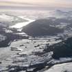
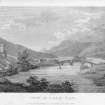
Loch Tay


General View (Period Unassigned)
Site Name Loch Tay
Classification General View (Period Unassigned)
Canmore ID 24452
Site Number NN63NE 106
NGR NN 6500 3600
NGR Description Centred on NN 6500 3600
Datum OSGB36 - NGR
Permalink http://canmore.org.uk/site/24452


- Council Perth And Kinross
- Parish Kenmore (Perth And Kinross)
- Former Region Tayside
- Former District Perth And Kinross
- Former County Perthshire
NN63NE 106 centred on 6500 3600
This site incorporates information from cancelled site

