
Pricing Change
New pricing for orders of material from this site will come into place shortly. Charges for supply of digital images, digitisation on demand, prints and licensing will be altered.
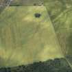
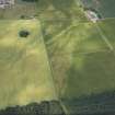
Oathlaw - Kirkbuddo


Roman Road (Roman)
Site Name Oathlaw - Kirkbuddo
Classification Roman Road (Roman)
Canmore ID 243976
Site Number NO45NE 86
NGR NO 4640 5530
NGR Description From NO 4640 5530 to NO 4655 5500
Datum OSGB36 - NGR
Permalink http://canmore.org.uk/site/243976


- Council Angus
- Parish Oathlaw
- Former Region Tayside
- Former District Angus
- Former County Angus
NO45NE 86 from 4640 5530 to 4655 5500. RX 17.
From the SE extremity of the southern rampart of Battledykes Roman Camp (NO45NE 12) begins what appears to be a Military Way which has extended between this camp and the one called Harefaulds (NO44SE 15). After running a little way E, it forms a sharp angle and turns suddenly down Lemno Burn.
Information from OS (JLD) 27 March 1958.
J Nichols 1780-90.
Jameson, in Gough's translation of 'Camden's "Britannia" (Camden 1806) gives an elaborate description of what he calls a 'Military Way' from the marching camp at Oathlaw (NO45NE 12) to that at Kirkbuddo (NO44SE 15). It was composed of 'rough, unpolished stones (commonly called bullet-stones) and earth,' and pursued a devious course with sharp turns.
This is plainly no Roman road, but the remains described no doubt did exist and were perhaps prehistoric.
Information from OS (JLD) 31 December 1951.
W Camden 1806.
No evidence for the course of this road could be found along the approximate course described by the authorities.
Visited by OS (JLD) 15 August 1958.
Possibly beginning at the SE extremity of the S rampart of Oathlaw Roman camp (NO45NE 12), the alleged Roman road to Kirkbuddo (NO44SE 15) heads in an eastern direction. It then turns S around NO 4655 5530.
Information from RCAHMS (no date).

