
Eigg, Galmisdale


No Class (Event) (Period Unassigned)
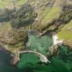
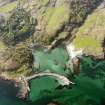
Site Name Eigg, Galmisdale
Classification No Class (Event) (Period Unassigned)
Alternative Name(s) Galmisdale Pier Development
Canmore ID 241922
Site Number NM48SE 39
NGR NM 4835 8380
NGR Description Centred on NM 4835 8380
Datum OSGB36 - NGR
Permalink http://canmore.org.uk/site/241922


- Council Highland
- Parish Small Isles
- Former Region Highland
- Former District Lochaber
- Former County Inverness-shire
NM48SE 39 centred on NM 4835 8380
NM 4835 8380 (centre) A desk-based assessment and rapid walkover survey were carried out over the area of the construction compound associated with the pier development. This was followed by the trial trenching of a 5% sample to check for buried archaeology. No visible archaeology was recorded. A diffuse scatter of lithics was recorded (during trial trenching) associated with a post-glacial raised beach in the N corner of the site. There were no features associated with the lithics.
A base-line survey of a wreck in Galmisdale Bay, recorded the previous year during an unusually low tide, was also carried out [NM48SE 8005].
Reports deposited in Highland SMR and the NMRS.
Sponsor: Highland Roads and Transport Consultancy.
M Wildgoose and M Birch 2002

