
Knockshinnie


Clearance Cairn(S) (Period Unassigned), Quarry (Period Unassigned)
Site Name Knockshinnie
Classification Clearance Cairn(S) (Period Unassigned), Quarry (Period Unassigned)
Canmore ID 241584
Site Number NX64NE 103
NGR NX 6822 4517
Datum OSGB36 - NGR
Permalink http://canmore.org.uk/site/241584

- Council Dumfries And Galloway
- Parish Kirkcudbright
- Former Region Dumfries And Galloway
- Former District Stewartry
- Former County Kirkcudbrightshire
NX64NE 103 6822 4517
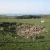
There are two heaps of field clearance in a small quarry on the SW flank of Knockshinnie. The quarry is depicted on the 1st edition of the OS 6-inch map (Kirkcudbrightshire 1854, sheet 54).
Visited by RCAHMS (DCC) 8 January 2003

