Pricing Change
New pricing for orders of material from this site will come into place shortly. Charges for supply of digital images, digitisation on demand, prints and licensing will be altered.
Auchindoir, St Mary's Church, Churchyard
Burial Ground (Medieval)
Site Name Auchindoir, St Mary's Church, Churchyard
Classification Burial Ground (Medieval)
Canmore ID 241255
Site Number NJ42SE 1.01
NGR NJ 47804 24545
Datum OSGB36 - NGR
Permalink http://canmore.org.uk/site/241255
- Council Aberdeenshire
- Parish Auchindoir And Kearn
- Former Region Grampian
- Former District Gordon
- Former County Aberdeenshire
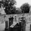
St Mary's Church, 13th century. This serene country kirkyard forms an important early group with the adjacent earthen castle motte, similar to the juxtaposition of Cunninghar motte and the old kirk of Midmar (qv). Early 16th-century
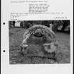
remodelling, 17th-century details. Unroofed 1810-11, the kirk is a long pink rectangle with, on south side, a fine Transitional Norman doorway with a chevron-moulded hood and nook shafts with bell capitals. A striking 16th-century sacrament house, shaped like a monstrance, is inserted into a lancet window in the north wall; also a Gordon of Craig armorial plaque of 1557 and a good grave slab of 1580. Ball-capped gatepiers; kirkyard walls 18th century.
Taken from "Aberdeenshire: Donside and Strathbogie - An Illustrated Architectural Guide", by Ian Shepherd, 2006. Published by the Rutland Press http://www.rias.org.uk


