
Following the launch of trove.scot in February 2025 we are now planning the retiral of some of our webservices. Canmore will be switched off on 24th June 2025. Information about the closure can be found on the HES website: Retiral of HES web services | Historic Environment Scotland
Clett


Stack Site (Period Unassigned)
Site Name Clett
Classification Stack Site (Period Unassigned)
Alternative Name(s) Burrier Head; Dale
Canmore ID 241
Site Number HU15SE 9
NGR HU 16910 52157
Datum OSGB36 - NGR
Permalink http://canmore.org.uk/site/241


- Council Shetland Islands
- Parish Walls And Sandness
- Former Region Shetland Islands Area
- Former District Shetland
- Former County Shetland
HU15SE 9 169 521.
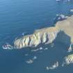
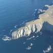
HU 169 522. There appear to be structures on the summit of the inaccessible Clett rock.
R G Lamb 1971.
Note (29 February 2016 - 18 May 2016)
Oblique aerial photography and satellite imagery suggest that the now inaccessible coastal stack on the N side of the Voe of Dale, has been occupied, though whether as a promontory fort, a monastic site, or indeed a more recent stronghold, is not known. Traces of a bank or ruined wall can be seen on the photographs at the ENE end of the summit of the promontory facing onto an impassable cleft eroded through the neck on the landward side. The bank appears to return westwards along the crest on the NNW to where there is apparently a cluster of rectangular structures occupying the seaward end. The enclosed area on the summit measures about 45m from ENE to WSW by between 9m and 20m transversely (0.07ha) but tails off into bare rock outcrops descending towards the sea on bothe the NNW and WSW. First noted from the neighbouring cliffs by Raymond Lamb (1971), for reasons unknown it was not included in his subsequent synthesis of the promontory forts of the Northern Isles (1980), and though it has never been visited there seems little doubt that this is some form of ancient promontory enclosure, its inaccessible position casting it alongside other promontory forts.
Information from An Atlas of Hillforts of Great Britain and Ireland – 18 May 2016. Atlas of Hillforts SC4175

