Following the launch of trove.scot in February 2025 we are now planning the retiral of some of our webservices. Canmore will be switched off on 24th June 2025. Information about the closure can be found on the HES website: Retiral of HES web services | Historic Environment Scotland
Eigg, Corragan Mor
Fort (Iron Age)
Site Name Eigg, Corragan Mor
Classification Fort (Iron Age)
Canmore ID 240681
Site Number NM48NE 56
NGR NM 49463 88748
Datum OSGB36 - NGR
Permalink http://canmore.org.uk/site/240681
- Council Highland
- Parish Small Isles
- Former Region Highland
- Former District Lochaber
- Former County Inverness-shire
Measured Survey (12 October 2002)
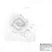
RCAHMS surveyed the fort at Corragan Mor on 12 October 2002 with plane-table and self-reducing alidade at a scale of 1:500. The plan was later used as the basis of an illustration that was published in 2016 (Hunter, fig. 3.18).
Note (12 November 2014 - 23 May 2016)
This small fortification occupies a craggy hillock that forms a pinnacle rising out of the top of a cone of talus at the foot of the cliffs on the E side of Eigg. The defences comprise a single wall dawn in a rough square around the outcrops, though even the scatter of stones that marks its course on the N and NE peters out on the SE; elsewhere on the NW and SW, around the margins of the terrace that forms the only occupiable space on the hillock, the wall forms a band of rubble about 2.5m in thickness along which a few inner and outer facing-stones are visible. The interior measures about 34m square (0.11ha), but two thirds of this is taken up by the boss of rock that gives the hillock its distinctive profile. The entrance is probably on the SE.
Information from An Atlas of Hillforts of Great Britain and Ireland – 23 May 2016. Atlas of Hillforts SC2525


