
Little Bruach-caoruinn


Corn Drying Kiln (Post Medieval), Cruck Framed Cottage (Post Medieval), Head Dyke (Post Medieval), Township (Post Medieval)
Site Name Little Bruach-caoruinn
Classification Corn Drying Kiln (Post Medieval), Cruck Framed Cottage (Post Medieval), Head Dyke (Post Medieval), Township (Post Medieval)
Alternative Name(s) Old Farms
Canmore ID 23935
Site Number NN40SW 8
NGR NN 4216 0069
Datum OSGB36 - NGR
Permalink http://canmore.org.uk/site/23935


- Council Stirling
- Parish Buchanan
- Former Region Central
- Former District Stirling
- Former County Stirlingshire
Field Visit (18 May 1955)
Old Farms, Little Bruach-caoruinn.
This settlement, which is marked on Grassom's map of 1817, stands rather less than a quarter of a mile SW. of the Duchray Water, on the left (NW.) bank of a small unnamed burn which joins the Duchray Water 270 yds. downstream from the confluence of the Bruach Caoruinn Burn. Its site is a shelf which slopes SE. towards the small burn and an intervening strip of wet ground, while further away, to E. and NE., there is the flatter valley bottom of the Duchray Water, which here lies at about 420 ft. O.D. Behind the settlement, to the NW., the ground rises to a low ridge, beyond which, about a quarter of a mile distant, lies the comparable settlement of Big Bruach-caoruinn (No. 379 [NN40SW 7]).
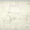
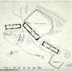
The Little Bruach-caoruinn settlement consists of three houses, with their outbuildings and enclosures, disposed as shown in Fig. 167. The houses are alined roughly crescent wise, along the contour, the lower side of the site being levelled up as a platform (infra). The following structural details were recorded about them in order from NE. to SW.
HOUSE A (Fig. 167, Pl. 206 A). This is the best preserved house in the group, and may be the most recent; its walls, at any rate, are thinner than those of the others. It measures externally about 73 ft. by 16 ft. 10 in., and is constructed of random rubble with mud mortar. The side walls are slightly battered, the height of the wallhead being about 7 ft.; both gables stand intact and are 11ft. high. The S. wall shows a splayed window and doorway, together with traces of what may have been a second doorway and a gap which may represent a third. Stones project from the wall-faces at certain points, no doubt for the attachment of ropes to retain the thatch; the E. gable has also two flat, projecting members, at a higher level than these stones, which probably served to ride the ropes clear of the wall-face. The internal arrangements are uncertain, but the building probably comprised a dwelling-house at the E. end and a byre, of smaller size, at the W. end. The presence of two doors in the E. portion suggests that this may itself have been subdivided. A pair of cruck-recesses in the E. portion are well preserved. Abutting on the outside of the E. gable are earthfast stones which suggest the foundations of a small outhouse.
HOUSE B (Fig. 167). This house, the central one of the group, is larger than its neighbours and somewhat irregular in shape, its external length averaging 88 ft. and its width varying from 17 ft. 8 in. to 21 ft. 6 in. The walls are built with mud mortar, the lateral ones being battered; the E. gable is 4 ft. thick and the other walls 3 ft. thick. The building is divided into three compartments, of which the two easternmost appear to have comprised a dwelling-house, with a central entrance flanked by splayed windows, while the W. one, which has a separate entrance, was presumably the byre. The E. partition, which subdivides the dwelling-house, probably had a doorway near its S. end for internal communication; the W. partition is built on the line of a cruck-frame and probably never rose to the full height of the roof.
HOUSE C (Fig. 167). This is the smallest of the three houses, measuring externally 63 ft. 6 in. in length and from 16 ft. 4 in. to 18 ft. 6 in. in breadth. It differs in plan from the others in the possession of two doors set opposite to one another in its long sides. The position of the internal partitions that may once have existed cannot now be determined, but the opposed doors could have served a feeding-walk (1), which could also have been used for winnowing, in a through current of air. The N. gable is intact, and stands to a height of 10 ft., the wall-head being at 5 ft. 6 in. The masonry both of the gable and of the surviving parts of the side walls is of high quality, and is clearly the work of a skilled craftsman; the gable, in particular, is excellently bonded and pinned, and has a perfectly uniform surface. High up on the outer face of the gable two stone thatch-pegs are symmetrically placed, and above them, 1 ft. below the apex, there are two projecting members similar to those noted on House A. There have evidently been four pairs of crucks, and the cruck-recesses that remain are very well preserved. No evidence as to the position of the fire was found in any of these houses. This suggests that use was made either of a central hearth, with a smoke-hole in the roof, or, more probably, of a chimney-hood of wood and clay fixed against the interior of a gable (2).
OUTBUILDINGS AND ENCLOSURES. The platform flanking the SE. fronts of the houses (supra) is about 12 ft. wide and has been carefully built up in places with drystone masonry. Below it the ground slopes gently towards the burn; the upper part of this slope is bounded at either end by a turf dyke, the one at the SW. end originating at the SE. corner of House C and standing to a height of3 ft. with a thickness of 4 ft. A roadway enters the enclosed space through a well-defined entrance in this dyke, but it fades out after passing a second dyke which comes down from the NE. corner of the same house; this second dyke is itself interrupted by an entrance into the smaller enclosure that the two dykes form in front of the house, and has on its N. side a small platform (D on Fig. 167). North of this again a hollow path leads up to the platform, and still further N. there is a small scooped-out enclosure (E on Fig. 167) which probably had a roof borne on posts, as two circular stones, suggestive of post-bases, flank its entrance. Another path leads up to the SW. end of House A and round its back, and at the NE. end of the enclosed strip, SE. of House A, there is a plot enclosed on three sides by turf dykes and on the fourth by the face of the platform. North of House B there lies a large enclosure of which the house itself forms the S. side; the other sides are formed by dykes of mixed stone and turf about 3 ft. high, with ditches 4 ft. wide outside them. A good deal of ground higher up the slope behind the houses has evidently been more or less improved and partially cleared of boulders. About 200 yds. SE. of the settlement there is a corn- drying kiln similar to the one at Big Bruach-caoruinn (cf. No. 379 [NN40SW 7]).
RCAHMS 1963, visited 18 May 1955
1 Peate, I., The Welsh House, 56.
2 An example of this type of chimney is illustrated in the
Inventory of Roxburghshire, fig. 46.
Laser Scanning (22 November 2017 - 24 November 2017)
NN 418 008 and NN 421 006
A laser scan survey of the farmsteads of Big Bruach Caoruinn and Wee Bruach Caoruinn was carried out, 22–24 November 2017. The survey used a Trimble TX5 laser scanner, and both a written and photographic record were also produced. The settlement of Big Bruach Caoruinn lies on the W bank of the Bruach Caoruinn Burn, 600m from its confluence with the Deuchray Water. The settlement is focused on two long buildings set at almost right angles to each other; alongside this there are two further, probably earlier, buildings, now reduced to turf-covered foundations, as well as a corn drying kiln and extensive remains of enclosures and field boundaries. The settlement of Wee Bruach Caoruinn lies on the NW bank of a small tributary of the Deuchray Water. The site occupies a SE-facing slope the lower side of which has been terraced to form a platform for the settlement. The site consists of three long buildings with outbuildings and enclosures, c300m to the SE of the site, on the opposite side of the stream there is a corn drying kiln.
Archive: NRHE (intended)Funder: Forestry Commission Scotland
Jamie Humble – AOC Archaeology Group (Source DES, Vol 19)
Note
A township annotated as Ruins and comprising three unroofed buildings, one of which is a long building and has an attached enclosure, and a head-dyke is depicted on the 1st edition of the OS 6-inch map (Stirlingshire 1864-5-6, sheet vi), but it is not shown on the current edition of the OS 1:10000 map (1976).
Information from RCAHMS (SAH) 21 January 1998

