
Following the launch of trove.scot in February 2025 we are now planning the retiral of some of our webservices. Canmore will be switched off on 24th June 2025. Information about the closure can be found on the HES website: Retiral of HES web services | Historic Environment Scotland
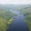
Island I Vow, Castle


Castle (16th Century)
Site Name Island I Vow, Castle
Classification Castle (16th Century)
Alternative Name(s) Ellan Vhow; Loch Lomond
Canmore ID 23837
Site Number NN31SW 2
NGR NN 33130 12737
Datum OSGB36 - NGR
Permalink http://canmore.org.uk/site/23837


- Council Argyll And Bute
- Parish Arrochar
- Former Region Strathclyde
- Former District Dumbarton
- Former County Dunbartonshire
NN31SW 2 33130 12737
(NN 3314 1272) Castle (NR) (Remains of)
OS 6" map, Dunbartonshire, 2nd ed., (1923)
When the castle at Inveruglas (NN30NW 2) was destroyed by Cromwell, the chief of the MacFarlanes took up residence at Tarbet (NN30SW 1) and Ellan Vhow, where the ruins of his Seat are still to be seen.
D Macleod 1891.
The castle was built in 1577 by Andrew MacFarlane. It measured 34' x 24', was very strongly built, and the ground floor was vaulted. The E and S walls are still in a tolerable state of preservation. The entrance seems to have been on the N. Around the castle are the ruins of small houses, in which probably resided the guard and retainers of the chief. It is mentioned also in 1581.
W Fraser 1869.
The remains of this building are in poor condition, but the walls, which are 1.0m thick are c. 7.0m high. A small vaulted compartment remains. The courses of two walls project northwards from the N wall, but may be the remains of a later building.
The remains of small rectangular buildings can be traced in thick vegetation to the W and N of the castle. Their walls are mainly drystone, although some parts are mortared. Although these buildings are undoubtedly of considerable age, their period of construction is not certain. The maximum height of these structures is 1.0m.
Visited by OS (J L D) 28 September 1956.
As described by previous OS field Surveyor.
Visited by OS (D W R) 4 March 1973.
Legend of a nunnery once having stood on the island and the name may be derived from Eilean Bhannaomh, Isle of the Holy Women but this probably refers to the unidentified island of Elanvanow.
The northernmost of Loch Lomond's islands, the castle was built in 1577 by Andrew MacFarlane. The castle stands at the southern edge of the island with a small bay immediately to the south. The bay is now filled with fallen masonry but a retaining wall can be seen on its western edge. In 1581 the dowager of the MacFarlane chief had a life rent on the castle from her son. The castle was occupied by the MacFarlanes as their principal residence after their castle on Inveruglas Isle was destroyed by Cromwell's troops in the mid 17th century. The MacFarlanes moved to a new house at Arrochar in 1697 and the castle was thereafter used as a storehouse.
The open area with no trace of buildings on the E side of the castle complex may have been used as gardens.
In the early 18th century (1743) the castle was described as a 'pretty good house with gardens' by Buchanan of Auchmar and Alexander of Duchray suggests the house was still inhabited in 1724. However, it was in ruins by 1814 when William Wordsworth visited Loch Lomond.
Enclosure walls can be traced along the west and south shores of the island respectively. The north shore is taken up with the jetty and breakwater and the main gravel beach where all boats land today. No trace of an enclosure wall could be detected along the east side and only occasional loose stones were encountered in this area. The relative emptiness of the eastern side of the island suggests it may have been used for livestock or small scale agricultural production or gardening. Alternatively, timber structures may have stood in this area though these would be undetectable without excavation or geophysical prospecting.
At the NW corner of the island is a rectangular building aligned E to W, and a hollow-way leads up from the shore past the east side of this building to a clear level area now used for barbecues. On the E side of this cleared area is an earth bank which runs N to S and forms an enclosing arm. From the SW corner of this bank an enclosure wall can be traced running off to the W and joining with the main enclosure wall along the W side of the island.
At the S end of the bank is a rectangular drystone structure which probably had an entrance on its N wall at the NW corner. This building appears to be more recent than the other rectangular drystone buildings associated with the castle. It remains standing to a greater height, has very little moss cover and is much less overgrown and denuded than the other structures.
To the south and within the area enclosed by walls, 2 rectangular drystone structures are to be found on the western side of the castleThe N of these is a two roomed structure aligned NE to SW and it appears to act as an enclosure building forming a courtyard area on the N side of the castle. A collapsed stone wall runs N from the NE corner of the castle and forms the other side of this courtyard area.
To the south and on the W side of the castle is a rectangular drystone building which remains standing to over a metre at its N end.
The castle is standing to the top of its first floor level in parts and there is the suggestion of a stairwell rising from the first floor in the SE internal corner. There is adequate fallen masonry, even though some may have been robbed, to suggest the castle had an upper storey and the remains of a fireplace can be seen at second floor level in the E wall.
The N wall of the castle is mostly collapsed above ground and first floor level and the W wall, the thinnest of the castle's walls, is in danger of collapse due to cracks in the stonework caused by ivy and the NW end of the W wall has already collapsed.
The S wall contains a large window at first floor level and also a smaller window or arrow slit which appears to have been altered during the castle?s occupation. A number of features suggest the castle was remodelled to the first floor E window in the S wall; the fireplace in the E wall at first floor level and the fireplace in the SW corner of the building at first floor level is obviously a later insertion.
The fine vaulted basement, or dungeon as it is locally known, is probably either a cellar or kitchen. A ventilation slit is present in both the N and S walls and 5 steps can be traced leading up into the E part of the castle. Drains emptying through both the E and S walls suggest the ground floor in the E half of the castle was occupied but it is now entirely filled with rubble up to the first floor level.
Immediately above the vault the first floor (ground) surface may be intact underneath the turf covering. It is likely that this area formed the hall of the castle, traditionally situated at first floor level. The large window in the S wall is placed directly above the vault and the later fireplace in the SW corner suggests that this was a living area as opposed to a kitchen or storage area.
The vaulted cellar has been cleared out in recent times and the collapsed masonry of the N wall has been cleared from around the cellar's ventilation slit on the N side. No obvious restoration works or excavation trenches were detected.
FIRAT 1995; NMRS, MS 993/2.
Scheduled as Island I Vow, castle and settlement, Loch Lomond.
Information from Historic Scotland, scheduling document dated 7 February 2005.
Note (1978)
Island I Vow NN 331 127 NN31SW 2
The remains of this castle stand on Island I Vow in Loch Lomond. It was built in 1577.
RCAHMS 1978
(Fraser 1869, ii, 78-9; Irving 1879, ii, 271)
Field Visit (13 June 2012)
NN 33130 12737 Ellan Vhow was visited during very low loch levels on 13 June 2012 to assess its condition five years after the last assessment in 2007. The low loch levels revealed that the entire island is fortified with a wall around the perimeter which is bonded with lime mortar in places. Five previously unidentified boat noosts and jetties were recorded and the remains of a quite elaborate jetty system/defended harbour on the N shore. Late medieval and post-medieval ceramic sherds were found on the shore and shaped roof slates suggest the tower had a turret. The survey in 2012 added nine new features to the 19 recorded in 1995. Wind blown trees that were adversely affecting the site were removed with scheduled monument consent on 7 August 2012.
Archive: Held by FAS until deposited in RCAHMS
Funder: Bruce McFarlin
Fiona Baker, Firat Archaeological Services Ltd
2012

