
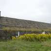
Lewis, Callanish, Tea Rooms


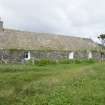
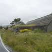
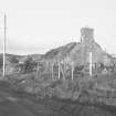
Blackhouse (Post Medieval), Cafe (Modern)
Site Name Lewis, Callanish, Tea Rooms
Classification Blackhouse (Post Medieval), Cafe (Modern)
Alternative Name(s) Black House; Calanais
Canmore ID 238331
Site Number NB23SW 78
NGR NB 21319 33158
Datum OSGB36 - NGR
Permalink http://canmore.org.uk/site/238331
Ordnance Survey licence number AC0000807262. All rights reserved.
Canmore Disclaimer.
© Bluesky International Limited 2025. Public Sector Viewing Terms
- Correction
- Favourite

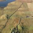
DP 110875
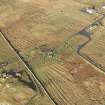
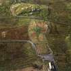
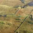
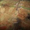
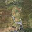
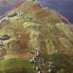
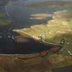
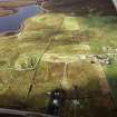
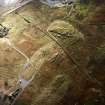
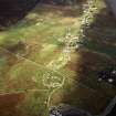
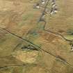
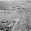
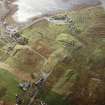
Oblique aerial view centred on the stone circle and stone row, the remains of the buildings and lazy beds at Calanais, taken from the SE.
RCAHMS Aerial Photography Digital
15/11/2011
© Crown Copyright: HES

SC 1692189
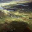
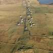
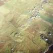
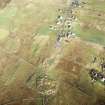
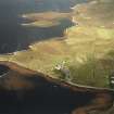
General oblique aerial view looking across the remains of the stone circle, stone alignments and township, taken from the SW.
RCAHMS Aerial Photography
24/9/2004
© Crown Copyright: HES

SC 1692190
General oblique aerial view looking across the remains of the stone circle, stone alignments and township, taken from the SW.
RCAHMS Aerial Photography
24/9/2004
© Crown Copyright: HES

SC 1692196
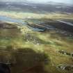
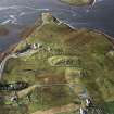
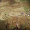
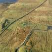
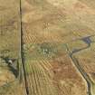
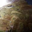
Oblique aerial view centred on the remains of the stone circle, chambered cairn and stone alignments with the township and lazy beds adjacent, taken from the WSW.
RCAHMS Aerial Photography
25/9/2004
© Crown Copyright: HES

SC 1692207
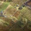
Oblique aerial view centred on the remains of the stone circle, chambered cairn and stone alignments with the township and lazy beds adjacent, taken from the NNE.
RCAHMS Aerial Photography
28/9/2004
© Crown Copyright: HES

SC 1692251
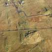
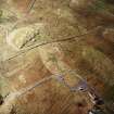
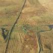
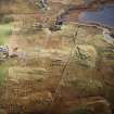
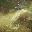
Oblique aerial view centred on the remains of the stone circle, chambered cairn and stone alignments with the blackhouse and lazy beds adjacent, taken from the NNE.
RCAHMS Aerial Photography
25/9/2004
© Crown Copyright: HES

SC 1692254
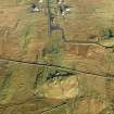
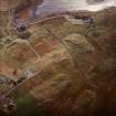
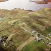
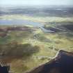
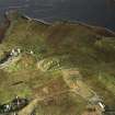
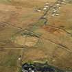
General oblique aerial view centred on the remains of the stone circle, chambered cairn and stone alignments with the farmhouse, visitor centre and township adjacent, taken from the NNE.
RCAHMS Aerial Photography
25/9/2004
© Crown Copyright: HES

SC 1692258
Oblique aerial view centred on the remains of the stone circle, chambered cairn and stone alignments with the blackhouse and lazy beds adjacent, taken from the NE.
RCAHMS Aerial Photography
25/9/2004
© Crown Copyright: HES

DP 108760
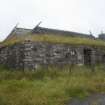
View from SSW
Records of the Royal Commission on the Ancient and Historical Monuments of Scotland (RCAHMS), Edinbu
11/8/2011
© Crown Copyright: HES

DP 110867
Oblique aerial view centred on the stone circle and stone row, the remains of the buildings and lazy beds at Calanais, taken from the SW.
RCAHMS Aerial Photography Digital
15/11/2011
© Crown Copyright: HES

DP 110868
Oblique aerial view centred on the stone circle and stone row, the remains of the buildings and lazy beds at Calanais, taken from the SSW.
RCAHMS Aerial Photography Digital
15/11/2011
© Crown Copyright: HES

DP 110874
Oblique aerial view centred on the stone circle and stone row, the remains of the buildings and lazy beds at Calanais, taken from the E.
RCAHMS Aerial Photography Digital
15/11/2011
© Crown Copyright: HES

DP 110879
Oblique aerial view centred on the stone circle and stone row, the remains of the buildings and lazy beds at Calanais, taken from the W.
RCAHMS Aerial Photography Digital
15/11/2011
© Crown Copyright: HES

SC 1655226
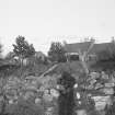
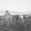
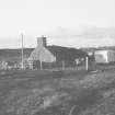
General view.
List C Survey
1975
© Crown Copyright: HES (List C Survey)

SC 1692185
Oblique aerial view centred on the remains of the stone circle and stone alignments with the township and lazy beds adjacent, taken from the W.
RCAHMS Aerial Photography
24/9/2004
© Crown Copyright: HES

SC 1692201
Oblique aerial view centred on the remains of the stone circle, chambered cairn and stone alignments with the township and lazy beds adjacent, taken from the NW.
RCAHMS Aerial Photography
28/9/2004
© Crown Copyright: HES

SC 1692203
Oblique aerial view centred on the remains of the stone circle, chambered cairn and stone alignments with the township and lazy beds adjacent, taken from the S.
RCAHMS Aerial Photography
28/9/2004
© Crown Copyright: HES

SC 1692205
Oblique aerial view centred on the remains of the stone circle, chambered cairn and stone alignments with the township and lazy beds adjacent, taken from the ESE.
RCAHMS Aerial Photography
28/9/2004
© Crown Copyright: HES

SC 1692206
Oblique aerial view centred on the remains of the stone circle, chambered cairn and stone alignments with the township and lazy beds adjacent, taken from the NE.
RCAHMS Aerial Photography
28/9/2004
© Crown Copyright: HES

SC 1692209
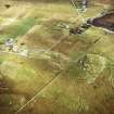
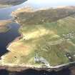
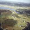
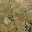
General oblique aerial view centred on the research centre, stone circle and stone alignments with the township adjacent, taken from the SW.
RCAHMS Aerial Photography
28/9/2004
© Crown Copyright: HES

SC 1692259
Oblique aerial view centred on the remains of the stone circle, chambered cairn and stone alignments with the blackhouse and lazy beds adjacent, taken from the NNE.
RCAHMS Aerial Photography
25/9/2004
© Crown Copyright: HES

DP 110872
General oblique aerial view centred on the stone circle and stone row, the remains of the buildings and lazy beds at Calanais on the Isle of Lewis, taken from the SSW.
RCAHMS Aerial Photography Digital
15/11/2011
© Crown Copyright: HES

DP 110873
General oblique aerial view centred on the stone circle and stone row, the remains of the buildings and lazy beds at Calanais, taken from the S.
RCAHMS Aerial Photography Digital
15/11/2011
© Crown Copyright: HES

DP 110878
Oblique aerial view centred on the stone circle and stone row, the remains of the buildings and lazy beds at Calanais, taken from the ENE.
RCAHMS Aerial Photography Digital
15/11/2011
© Crown Copyright: HES

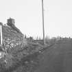
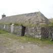
SC 1655224
General view.
List C Survey
1975
© Crown Copyright: HES (List C Survey)


SC 1692186
Oblique aerial view centred on the remains of the stone circle and stone alignments with the township and lazy beds adjacent, taken from the SW.
RCAHMS Aerial Photography
24/9/2004
© Crown Copyright: HES

SC 1692187
Oblique aerial view centred on the remains of the stone circle and stone alignments with the township and lazy beds adjacent, taken from the SSW.
RCAHMS Aerial Photography
24/9/2004
© Crown Copyright: HES

SC 1692193
Oblique aerial view centred on the remains of the stone circle, chambered cairn and stone alignments with the township and lazy beds adjacent, taken from the SSE.
RCAHMS Aerial Photography
25/9/2004
© Crown Copyright: HES

SC 1692194
Oblique aerial view centred on the remains of the stone circle, chambered cairn and stone alignments with the township and lazy beds adjacent, taken from the NNE.
RCAHMS Aerial Photography
25/9/2004
© Crown Copyright: HES

SC 1692234
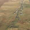
General oblique aerial view looking across the remains of the stone circle, stone alignments and township, taken from the SE.
RCAHMS Aerial Photography
24/9/2004
© Crown Copyright: HES

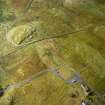
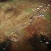
SC 958513
Oblique aerial view centred on the remains of the stone circle, chambered cairn and stone alignments with the township and lazy beds adjacent, taken from the NE.
RCAHMS Aerial Photography
28/9/2004
© Crown Copyright: HES

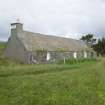
DP 004819
View from SE
Records of the Royal Commission on the Ancient and Historical Monuments of Scotland (RCAHMS), Edinbu
5/8/2005
© Crown Copyright: HES

DP 004822
View from NW
Records of the Royal Commission on the Ancient and Historical Monuments of Scotland (RCAHMS), Edinbu
5/8/2005
© Crown Copyright: HES

SC 1692184
Oblique aerial view centred on the remains of the stone circle and stone alignments with the township and lazy beds adjacent, taken from the NE.
RCAHMS Aerial Photography
24/9/2004
© Crown Copyright: HES

SC 1692256
General oblique aerial view centred on the remains of the stone circle, chambered cairn and stone alignments with the farmhouse, visitor centre and township adjacent, taken from the ESE.
RCAHMS Aerial Photography
25/9/2004
© Crown Copyright: HES

DP 108762
View from SE
Records of the Royal Commission on the Ancient and Historical Monuments of Scotland (RCAHMS), Edinbu
11/8/2011
© Crown Copyright: HES

SC 1692183
Oblique aerial view centred on the remains of the stone circle and stone alignments with the township and lazy beds adjacent, taken from the ESE.
RCAHMS Aerial Photography
24/9/2004
© Crown Copyright: HES

SC 1692197
Oblique aerial view centred on the remains of the stone circle, chambered cairn and stone alignments with the township and lazy beds adjacent, taken from the S.
RCAHMS Aerial Photography
25/9/2004
© Crown Copyright: HES

SC 1692204
Oblique aerial view centred on the remains of the stone circle, chambered cairn and stone alignments with the township and lazy beds adjacent, taken from the SE.
RCAHMS Aerial Photography
28/9/2004
© Crown Copyright: HES

SC 1692208
Oblique aerial view centred on the remains of the stone circle, chambered cairn and stone alignments with the township and lazy beds adjacent, taken from the NNW.
RCAHMS Aerial Photography
28/9/2004
© Crown Copyright: HES

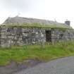
DP 004820
View from E
Records of the Royal Commission on the Ancient and Historical Monuments of Scotland (RCAHMS), Edinbu
5/8/2005
© Crown Copyright: HES

DP 108761
View from W
Records of the Royal Commission on the Ancient and Historical Monuments of Scotland (RCAHMS), Edinbu
11/8/2011
© Crown Copyright: HES

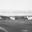
SC 1655225
General view from NE.
List C Survey
1975
© Crown Copyright: HES (List C Survey)

SC 1655228
General view.
List C Survey
1975
© Crown Copyright: HES (List C Survey)

SC 1692044
General oblique aerial view looking across the remains of the stone circle, stone alignments and township, taken from the SSW.
RCAHMS Aerial Photography
24/9/2004
© Crown Copyright: HES

SC 1692045
General oblique aerial view looking across the remains of the stone circle, stone alignments and township, taken from the S.
RCAHMS Aerial Photography
24/9/2004
© Crown Copyright: HES

SC 1692182
Oblique aerial view centred on the remains of the stone circle and stone alignments with the township and lazy beds adjacent, taken from the SSE.
RCAHMS Aerial Photography
24/9/2004
© Crown Copyright: HES

DP 110869
Oblique aerial view centred on the stone circle and stone row, the remains of the buildings and lazy beds at Calanais, taken from the SSE.
RCAHMS Aerial Photography Digital
15/11/2011
© Crown Copyright: HES

DP 110870
Oblique aerial view centred on the stone circle and stone row, the remains of the buildings and lazy beds at Calanais, taken from the SE.
RCAHMS Aerial Photography Digital
15/11/2011
© Crown Copyright: HES

DP 110876
Oblique aerial view centred on the stone circle and stone row, the remains of the buildings and lazy beds at Calanais, taken from the ESE.
RCAHMS Aerial Photography Digital
15/11/2011
© Crown Copyright: HES

DP 110877
Oblique aerial view centred on the stone circle and stone row, the remains of the buildings and lazy beds at Calanais, taken from the E.
RCAHMS Aerial Photography Digital
15/11/2011
© Crown Copyright: HES

SC 1528133
Oblique aerial view of Callanish stone circle and stone row, Lewis.
John Dewar
1966
© Copyright: HES (John Dewar Collection)

SC 1692200
Oblique aerial view centred on the remains of the stone circle, chambered cairn and stone alignments with the township and lazy beds adjacent, taken from the N.
RCAHMS Aerial Photography
28/9/2004
© Crown Copyright: HES

SC 1692202
Oblique aerial view centred on the remains of the stone circle, chambered cairn and stone alignments with the township and lazy beds adjacent, taken from the W.
RCAHMS Aerial Photography
28/9/2004
© Crown Copyright: HES

SC 1692257
General oblique aerial view centred on the remains of the stone circle, chambered cairn and stone alignments with the farmhouse, visitor centre and township adjacent, taken from the NE.
RCAHMS Aerial Photography
25/9/2004
© Crown Copyright: HES

DP 004821
View from NE
Records of the Royal Commission on the Ancient and Historical Monuments of Scotland (RCAHMS), Edinbu
5/8/2005
© Crown Copyright: HES

SC 1655223
General view.
List C Survey
1975
© Crown Copyright: HES (List C Survey)

DP 110880
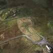
General oblique aerial view centred on the stone circle and stone row, the remains of the buildings and lazy beds at Calanais with the visitor centre in the foreground, taken from the S.
RCAHMS Aerial Photography Digital
15/11/2011
© Crown Copyright: HES

SC 1692188
Oblique aerial view centred on the remains of the stone circle and stone alignments with the township and lazy beds adjacent, taken from the S.
RCAHMS Aerial Photography
24/9/2004
© Crown Copyright: HES

SC 1692195
Oblique aerial view centred on the remains of the stone circle, chambered cairn and stone alignments with the township and lazy beds adjacent, taken from the NNW.
RCAHMS Aerial Photography
25/9/2004
© Crown Copyright: HES

SC 1692210
General oblique aerial view centred on the research centre, stone circle and stone alignments with the township adjacent, taken from the SSE.
RCAHMS Aerial Photography
28/9/2004
© Crown Copyright: HES

SC 1692255
General oblique aerial view centred on the remains of the stone circle, chambered cairn and stone alignments with the farmhouse, visitor centre and township adjacent, taken from the ESE.
RCAHMS Aerial Photography
25/9/2004
© Crown Copyright: HES
- Council Western Isles
- Parish Uig
- Former Region Western Isles Islands Area
- Former District Western Isles
- Former County Ross And Cromarty

