
Following the launch of trove.scot in February 2025 we are now planning the retiral of some of our webservices. Canmore will be switched off on 24th June 2025. Information about the closure can be found on the HES website: Retiral of HES web services | Historic Environment Scotland
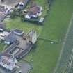
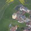
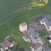
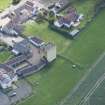
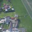
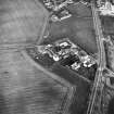
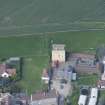
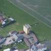
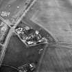
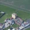
Edinburgh, 142 Liberton Drive, Tower House


Farmhouse (18th Century), Tower House (Medieval)
Site Name Edinburgh, 142 Liberton Drive, Tower House
Classification Farmhouse (18th Century), Tower House (Medieval)
Alternative Name(s) Liberton Tower
Canmore ID 236780
Site Number NT26NE 209
NGR NT 26518 69660
Datum OSGB36 - NGR
Permalink http://canmore.org.uk/site/236780


- Council Edinburgh, City Of
- Parish Edinburgh (Edinburgh, City Of)
- Former Region Lothian
- Former District City Of Edinburgh
- Former County Midlothian
NT26NE 209.00 26518 69660
NT26NE 209.01 26538 69676 Outbuildings and Stables
NT26NE 209.02 26526 69634 Boundary Walls and Gate-piers
Liberton Tower [NR]
OS 1:50,000 map, 1999.
Watching Brief (6 June 2011)
NT 26551 69682 A watching brief was carried out in June 2011 during groundworks associated with the construction of a house extension at 4 Liberton Tower Lane. The site was considered sensitive as it is adjacent to the Category A listed 15th-century Liberton Tower, a Category C listed early 18th-century farmhouse, and a Category B listed late 18th-century farmhouse. No features, deposits or artefacts of archaeological significance were recorded.
Archive: RCAHMS. Report: City of Edinburgh Council SMR
Funder: Mr Frank Pritchard
CFA Archaeology 2011 (G. Savory) OASIS ID: cfaarcha1-102922

