
Scheduled Maintenance
Please be advised that this website will undergo scheduled maintenance on the following dates: •
Tuesday 3rd December 11:00-15:00
During these times, some services may be temporarily unavailable. We apologise for any inconvenience this may cause.
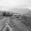
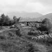
Blarmachfoldach


Township (Period Unassigned)
Site Name Blarmachfoldach
Classification Township (Period Unassigned)
Alternative Name(s) Blarmach Foldach
Canmore ID 23563
Site Number NN06NE 3
NGR NN 097 692
NGR Description NN c. 097 692
Datum OSGB36 - NGR
Permalink http://canmore.org.uk/site/23563


- Council Highland
- Parish Kilmallie
- Former Region Highland
- Former District Lochaber
- Former County Inverness-shire
Note
A crofting township, comprising forty-eight roofed, two partially roofed and three unroofed buildings is depicted on the 1st edition of the OS 6-inch map (Inverness-shire 1873, sheet clx). Twenty-three roofed buildings, one partially roofed building and fourteen unroofed buildings are shown on the current edition of the OS 1:10000 map (1988).
Information from RCAHMS (AKK) 20 September 1996.

