
Following the launch of trove.scot in February 2025 we are now planning the retiral of some of our webservices. Canmore will be switched off on 24th June 2025. Information about the closure can be found on the HES website: Retiral of HES web services | Historic Environment Scotland
Currie, Kirkgate, Currie Kirk, Burial Ground


Burial Ground (Post Medieval), Churchyard (Post Medieval), Cross Slab(S) (Early Medieval)
Site Name Currie, Kirkgate, Currie Kirk, Burial Ground
Classification Burial Ground (Post Medieval), Churchyard (Post Medieval), Cross Slab(S) (Early Medieval)
Alternative Name(s) Churchyard
Canmore ID 235499
Site Number NT16NE 18.01
NGR NT 18318 67610
Datum OSGB36 - NGR
Permalink http://canmore.org.uk/site/235499


- Council Edinburgh, City Of
- Parish Currie
- Former Region Lothian
- Former District City Of Edinburgh
- Former County Midlothian
NT16NE 18.01 18318 67610
For modern cemetery see NT16NE 198
INVENTORY OF GRAVEYARD AND CEMETERY SITES IN SCOTLAND REFERENCE:
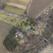
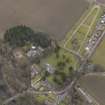
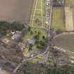
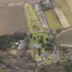
Address: Currie Kirk Burial Ground, Kirkgate, Currie
Postcode: EH14 6AL
Status: Unknown
Size: 0.63 hectares, 1.56 acres
Polygon: No
TOIDs:
Number of gravestones: Not Known
Earliest gravestone: Not Known
Most recent gravestone: Not Known
Description: Burial ground associated with a church
Data Sources: OS MasterMap checked 13 September 2005; Bereavement Services Portal checked 13 September 2005
Field Visit (28 August 1920)
Parish Church, Currie.
The ruin of the choir of the old parish church of Kinleith or Currie is utilised as a burial enclosure, and stands detached some yards eastward from the present church, but within the churchyard. The structure, which is oblong on plan and is orientated measures 31 feet in length by 23 feet in breadth. The only features remaining, though barely traceable since the last repointing, are a built-up window and doorway in the south wall; these are chamfered on jambs and head. The heads are wrought from a single stone; that of the window is semicircular, while that of the doorway is three-sided. These features are not later than the 15th century. Within the enclosure are several mural tombstones, the earliest commemorating Robert Clayhills, eldest son of the laird of Innergowrie, who died in 1670. The pediment of this memorial contains the Clayhills arms, viz., parted per bend, two greyhounds courant bend-ways.*
RECUMBENT SLABS. (1) Within the churchyard, about 20 feet south of the church, is a recumbent slab, 4 feet 10 inches by 1 foot 4inches by 6 ½ inches, bordered by an angle bead. At the head is a circular panel with an articulated border, containing in relief a cross-patty. Beneath the panel is incised a sword with depressed quillons and rounded pommel; on the left of the sword there appears to be a scabbard. The workmanship is crude. This slab (Fig. 85) may be related to the two following now preserved in the vestibule of the church.
(2) This stone measures 2 feet 8 inches by 11 inches by 4 inches, is back-set and contains across-head similar to (1), but the cross in this instance is canted; beneath the head a shaft is incised, very crookedly, with calvary, capital and two sur-bases. On the right of the shaft a dagger is incised, and on the left what may be a pair of shears* (Fig. 83).
(3) The other measures 2 feet 4 inches by 10 inches by 5 inches, is similarly bordered and has a cross-head similar to (1). Beneath the panels is a shaft with upper arm and calvary. On the left and linked to the shaft a pair of shears are incised* (Fig. 83).
RCAHMS 1929, visited 28 August 1920.
*Cf. Proc. Soc. Ant. Scot., xl (1905-6), p. 228.
Project (1997)
The Public Monuments and Sculpture Association (http://www.pmsa.org.uk/) set up a National Recording Project in 1997 with the aim of making a survey of public monuments and sculpture in Britain ranging from medieval monuments to the most contemporary works. Information from the Edinburgh project was added to the RCAHMS database in October 2010 and again in 2012.
The PMSA (Public Monuments and Sculpture Association) Edinburgh Sculpture Project has been supported by Eastern Photocolour, Edinburgh College of Art, the Edinburgh World Heritage Trust, Historic Scotland, the Hope Scott Trust, The Old Edinburgh Club, the Pilgrim Trust, the RCAHMS, and the Scottish Archive Network.
Watching Brief (18 October 2011)
AOC archaeology group carried out a monitored topsoil strip on the site of a proposed extension to Currie Kirk. The striping of the topsoil and disturbed ground found at three burials (left in situ), and the remains of a large wall probably associated with an earlier phase of the church.
Erlend Hindmarch (AOC Archaeology Group) October 2011. OASIS-id: aocarcha1-112721

