
Pricing Change
New pricing for orders of material from this site will come into place shortly. Charges for supply of digital images, digitisation on demand, prints and licensing will be altered.
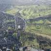
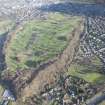
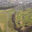
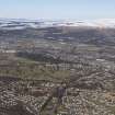
Stirling Castle, King's Park And Boundary Wall


Park (Period Unassigned), Park Wall (Medieval), Park Wall (Post Medieval)
Site Name Stirling Castle, King's Park And Boundary Wall
Classification Park (Period Unassigned), Park Wall (Medieval), Park Wall (Post Medieval)
Canmore ID 235460
Site Number NS79SE 6.16
NGR NS 78468 93175
NGR Description Centred NS 78468 93175
Datum OSGB36 - NGR
Permalink http://canmore.org.uk/site/235460


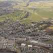


- Council Stirling
- Parish Stirling
- Former Region Central
- Former District Stirling
- Former County Stirlingshire
NS79SE 6.16 centred 78468 93175
Watching Brief (5 May 2010 - 12 May 2010)
NS 7904 9306
A watching brief was undertaken 5–12 May 2010 on top soil stripping and excavations associated with the construction of a new footpath in King’s Park. The site was considered archaeologically sensitive as a previous investigation in the 1970s recorded the remains of a Roman road just inside the park’s main SE gateway. There is also written evidence of practice trenches being excavated near
the route of the pathway during WW1. The watching brief recorded one cut feature that could possibly be the result of activity during WW1 and a deposit of what was considered to be in situ natural gravel at the S end of the trench. In general, the deposits comprised natural sands and gravels below stony topsoil and subsoil.
Archive: RCAHMS
Funder: Stirling Council
R Cathcart 2010
Field Visit (24 January 2013)
A photographic record was made of the park wall.
Visited by RCAHMS (PJD, SD) 24 January 2013

