Accessibility

Font Size

100% 150% 200%

Background Colour

Default Contrast
Close Reset

Kilchrenan Parish Church

Burial Ground (Post Medieval), Church (18th Century) (1770), Churchyard (Post Medieval)

Site Name Kilchrenan Parish Church

Classification Burial Ground (Post Medieval), Church (18th Century) (1770), Churchyard (Post Medieval)

Canmore ID 23468

Site Number NN02SW 11

NGR NN 03641 22906

Datum OSGB36 - NGR

Permalink http://canmore.org.uk/site/23468

Ordnance Survey licence number AC0000807262. All rights reserved.
Canmore Disclaimer. © Bluesky International Limited 2025. Public Sector Viewing Terms

Toggle Aerial | View on large map

Digital Images

Kilchrenan Parish Church, NN02SW 11, Ordnance Survey index card, Recto
Kilchrenan Parish Church, NN02SW 11, Ordnance Survey index card, RectoKilchrenan Parish Church, McIntyre Monument.
General view of monument.
View of inscription from a late medieval grave slab, of Dugullas MacKellar, from Kilchrenan Churchyard, Kilchrenan, Argyll. Inscription translates as, 'Here lies Dugallas MacKellar, and Colinus, son of Angusius, made it.'
Titled: 'In Kilchrenan Churchyard. an inscription.'​
PHOTOGRAPH ALBUM NO 186: J B MACKENZIE ALBUMS vol.1Cross slab, Kilchrenan.Oblique aerial view of Kilchrenan, taken from the north, centred on the church.Kilchrenan Parish Church, NN02SW 11, Ordnance Survey index card, page number 2, VersoKilchrenan Parish Church.
General view from South-West.Kilchrenan, graveslab.
General view of grave slab of Dugallus MacKellar.Oblique aerial view of Kilchrenan, taken from the north west, centred on the church.Kilchrenan Parish Church.
General view from South-West.Kilchrenan Parish Church.
General view from South-East.Kilchrenan Parish Church.
General view from South.Kilchrenan Parish Church.
General view from South-West.View of two 19th century grave slabs in the graveyard of Kilchrenan Parish Church, Kilchrenan and Dalavich, Argyll. On the left, the memorial to Margaret Crawford Mackenzie (d1861), erected by her husband John Williams; on the right the memorial to Elizabeth nee Crawford (d1864), wife of Rev. Neil Mackenzie, the incumbent at Kilchrenan, but particularly well known for hs ministry of St Kilda from 1830-1844. Margaret was presumably the daughter of Neil and Elizabeth. 
Titled: '152. at Kilchrenan.'
PHOTOGRAPH ALBUM NO 186: J B MACKENZIE ALBUMS vol.1View of late medieval grave slab, with inscription, from Kilchrenan Parish Churchyard, Lochawe.
Titled: '157. At Kilchrenan. Cailein Mori?.'
PHOTOGRAPH ALBUM NO 186: J B MACKENZIE ALBUMS vol.1View of late medieval carved stone, from Kilchrenan Parish Churchyard, Lochawe.
Titled: '160. At Kilchrenan.'
PHOTOGRAPH ALBUM NO 186: J B MACKENZIE ALBUMS vol.1View of late medieval carved stone cross slab, from Kilchrenan Parish Churchyard, Lochawe.
Titled: '161. At Kilchrenan.'
PHOTOGRAPH ALBUM NO 186: J B MACKENZIE ALBUMS vol.1View of late medieval carved stone, from Kilchrenan Parish Churchyard, Lochawe.
Titled: '163. At Kilchrenan.'
PHOTOGRAPH ALBUM NO 186: J B MACKENZIE ALBUMS vol.1Unidentified cross slab.Oblique aerial view of Kilchrenan, taken from the north west, centred on the church.Kilchrenan Parish Church, NN02SW 11, Ordnance Survey index card, VersoView of late medieval grave slab, from Kilchrenan Parish Churchyard, Lochawe.
Titled: '159. At Kilchrenan.'
PHOTOGRAPH ALBUM NO 186: J B MACKENZIE ALBUMS vol.1Oblique aerial view of Kilchrenan, taken from the south, centred on the church.Kilchrenan Parish Church.
General view from South-East.Kilchrenan Parish Church, NN02SW 11, Ordnance Survey index card, page number 3, RectoKilchrenan Parish Church, interior.
General view from West.Kilchrenan Parish Church.
General view from South-West.Kilchrenan Parish Church, McIntyre tablet.
General view of monument in South wall.View of man lying in front of the Oratory at Kilchrenan Parish Churchyard, Lochawe.
Titled: '162. Oratory at Kilchrenan, Lochawe.'
PHOTOGRAPH ALBUM NO 186: J B MACKENZIE ALBUMS vol.1Oblique aerial view of Kilchrenan, taken from the north, centred on the church.Kilchrenan Parish Church.
General view from South-East.View of a 19th century grave slab, that of Edward Bethell Codrington, in the graveyard of Kilchrenan Parish Church, Kilchrenan and Dalavich, Argyll.
Titled: '136. in Kilchrenan Churchyard.'
PHOTOGRAPH ALBUM NO 186: J B MACKENZIE ALBUMS vol.1View of late medieval grave slab, from Kilchrenan Parish Churchyard, Lochawe.
Titled: '158. At Kilchrenan. McArthurs.'
PHOTOGRAPH ALBUM NO 186: J B MACKENZIE ALBUMS vol.1View of Kilchrenan Parish Church and surrounding landscape at Lochawe, Kilchrenan and Dalavich, Argyll.
Titled: '154. Kilchrenan Church, Lochawe.'
PHOTOGRAPH ALBUM NO 186: J B MACKENZIE ALBUMS vol.1View of a 19th century memorial, in the graveyard of Kilchrenan Parish Church, Kilchrenan and Dalavich, Argyll.
Titled: '169. at Kilchrenan.'
PHOTOGRAPH ALBUM NO 186: J B MACKENZIE ALBUMS vol.1Kilchrenan Parish Church, NN02SW 11, Ordnance Survey index card, page number 1, RectoKilchrenan Parish Church, interior.
General view from West.

Administrative Areas

  • Council Argyll And Bute
  • Parish Kilchrenan And Dalavich
  • Former Region Strathclyde
  • Former District Argyll And Bute
  • Former County Argyll

Archaeology Notes

NN02SW 11.00 03651 22906. Kilchrenan Church

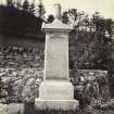
NN02SW 11.01 NN 03642 22920 Robert Macintyre Monument

(NN 0365 2290) Church (NAT)

OS 1:10,000 map, (1975)

The parish church of Kilchrenan served a parish which, in the medieval period included lands on the east and west shores of Loch Awe, and until the 17th century was known simply as the church 'of Lochaw'. The parish is first noted in records in the 14th century but there is architectural evidence for the construction of a church in the 13th century. The original dedication was to the Irish Saint Chreathanan (Scott et al 1915-61) but this was superseded by a later dedication to St Peter the Deacon, perhaps a reference to the person of that name who was secretary and companion to St Gregory the Great.

The dimensions and orientation of the present building, which dates from 1771, are similar to those of several medieval churches in Lorn and it is possible that it stands on the foundations of, or incorporates some of the masonry of its 13th century predecessor. By 1807, it had fallen into general disrepair necessitating urgent attention, and in 1904 extensive alterations were made to the interior and subsequently a vestry was added on the north side.

The building, which stands, within a churchyard enclosed by a modern boundary wall, is rectangular, measuring 15.1 metres E-W by 6 metres transversely within walls up to one metre thick.

The principle interest of the exterior is in the south facade which is a well-preserved specimen of 18th century design.

Built against the east part of the south wall is a burial enclosure dated 1779 which may mark the position of an earlier one added against the south wall of the medieval church.

A number of incised stone slabs are to be found in the churchyard, some of which date from as early as the 13th and 14th centuries.

RCAHMS 1975, visited August 1970; H Scott et al 1915-61.

There is not trace of any earlier structures on this site.

Surveyed at 1:2500 scale.

Visited by OS (D W R) 8 November 1971.

Activities

Aerial Photography (2 June 1997)

References

MyCanmore Image Contributions


Contribute an Image

MyCanmore Text Contributions