
Caisteal Suidhe Cheannaidh


Dun (Later Prehistoric), Hut (Medieval) - (Post Medieval)
Site Name Caisteal Suidhe Cheannaidh
Classification Dun (Later Prehistoric), Hut (Medieval) - (Post Medieval)
Canmore ID 23466
Site Number NN02SW 1
NGR NN 02954 24230
Datum OSGB36 - NGR
Permalink http://canmore.org.uk/site/23466


- Council Argyll And Bute
- Parish Kilchrenan And Dalavich
- Former Region Strathclyde
- Former District Argyll And Bute
- Former County Argyll
NN02SW 1 02954 24230.
(NN 0294 2423) Dun (NR) Caisteal Suidhe Cheannaidh (NAT)
OS 1:10,000 map, (1975)
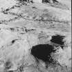
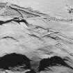
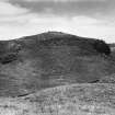
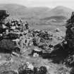
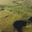
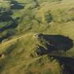
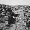
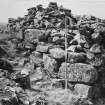
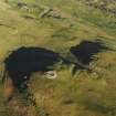
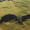
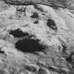
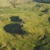
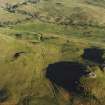
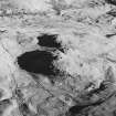
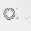
On the highest part of the east end of a rocky ridge, are the remains of one of the best preserved duns in Lorn. It is protected by steep slopes on all sides except the west where there is a gentle approach along the crest of the ridge. The dun is almost circular on plan, measuring 11.9 by 13.1 metres within a wall up to 4.9 metres thick. The outer face, which consists of large stones survives to a maximum height of over 2 metres on the west whilst the inner face still stands to an average height of 2 metres in about nine courses, but the base of the wall on both sides is now largely obscured by fallen debris. It is recorded that, before being used as a quarry for field walls, it stood 6 metres high. The entrance is on the NE side, the outer corners being formed of large blocks. The passage is checked for a door at a point 1.7 metres from the outside from where it widens to 2.1 metres. The inner portion of the passage is 2.4 metres long and has slightly curved sides. During excavation in 1890 several hearths were discovered as well as bones of horse and deer.
RCAHMS 1975; D Christison 1891.
As described. Name not confirmed.
Surveyed at 1:10 000 scale.
Visited by OS (R D) 29 October 1969.
Field Visit (June 1969)
NN 029 242. One of the best-preserved duns in Lorn occupies a commanding position overlooking the valley that runs between Taynuilt and Kilchrenan. It stands on the highest part of the E end of a rock ridge (210m OD) situated 1.55 km NW of Kilchrenan, and is protected by steep slopes on all sides except on the W where there is a gentle approach along the crest of the ridge. Almost circular on plan (Fig. 54), the dun measures 11'9 m by 13'1 m within a wall up to 4'9 m thick. The outer face, which consists of large stones measuring 1·65 m by 0·6 m and 0'45 m in thickness, rises with a slight batter to a maximum height of over 2 m on the W. The inner face of the wall still stands to an average height of 2 m in about nine courses, but the base of the wall on both sides is now largely obscured by fallen debris. It is recorded (PSAS, xxv (1890-1), 118-27) that it stood to a height of about 6 m before it was used as a quarry for field walls. The entrance is on the NE side and measures 1'75 m externally, with large blocks forming the outer corners. The passage is checked for a door at a point 1'7 m from the outside, where it widens to 2'1 m. The inner portion of the passage, 2'4 m in length, has slightly curved sides which seem to be corbelled inwards at the top, but this may have been due to the settlement of the stones. Some excavation was undertaken in the interior in 1890 (Ibid), in the course of which several hearths were discovered, as well as the bones of horse and deer.
RCAHMS 1975, visited June 1969.
Measured Survey (1969)
Surveyed with alidade and plane-table at 1mm:1ft. Redrawn in ink and published at the reduced scale of 1:1000 (RCAHMS 1975, fig. 54).
Field Visit (3 June 1996)
NN02SW 1 02954 24230.
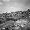
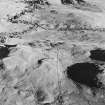
This dun (LORN96 3) is situated on the E end of a rocky ridge that commands extensive views to the S and E. The flanks of the ridge are precipitous on all sides except the E, where there is a gentle approach to the dun along the crest. The dun is almost circular on plan, measuring 13.3m from ENE to WSW by 12m transversely within a wall 4.5m in thickness and up to 2m in height. The wall is constructed of massive rubble blocks, exposed around most of the circuit by the removal of tumble. The entrance passage, on the ENE, is checked for a door and looks directly across to Ben Cruachan.
The coursed rubble footings of a rectangular hut (LORN96 4) are set against a rock outcrop immediately to the N of the dun. It measures 2.7m from NNE to SSW by 1.3m transversely within footings 0.7m in thickness and 0.3m in height.
(LORN96 3, 4)
Visited by RCAHMS (DCC) 3 June 1996

