
Oban, Rockfield Road, Primary School With Boundary Walls And Play Shelter


School (19th Century)
Site Name Oban, Rockfield Road, Primary School With Boundary Walls And Play Shelter
Classification School (19th Century)
Canmore ID 233818
Site Number NM82NE 147
NGR NM 86046 29952
Datum OSGB36 - NGR
Permalink http://canmore.org.uk/site/233818
Ordnance Survey licence number AC0000807262. All rights reserved.
Canmore Disclaimer.
© Bluesky International Limited 2025. Public Sector Viewing Terms
- Correction
- Favourite

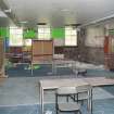
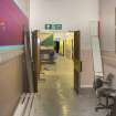
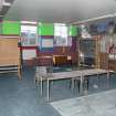
DP 222989
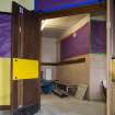
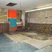
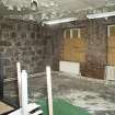
General view of former hall looking through to the canteen.
Records of the Royal Commission on the Ancient and Historical Monuments of Scotland (RCAHMS), Edinbu
3/9/2015
© Crown Copyright: HES

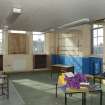
DP 222996
General view of double classroom at South on first floor.
Records of the Royal Commission on the Ancient and Historical Monuments of Scotland (RCAHMS), Edinbu
3/9/2015
© Crown Copyright: HES

DP 223010
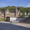
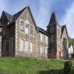
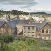
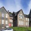
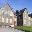
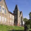
General view from West showing school and ancillary buildings.
Records of the Royal Commission on the Ancient and Historical Monuments of Scotland (RCAHMS), Edinbu
3/9/2015
© Crown Copyright: HES

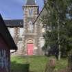
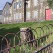
DP 223024
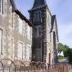
General view from North West showing tower and railings.
Records of the Royal Commission on the Ancient and Historical Monuments of Scotland (RCAHMS), Edinbu
3/9/2015
© Crown Copyright: HES

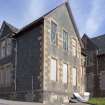
DP 222983
General view from North West
Records of the Royal Commission on the Ancient and Historical Monuments of Scotland (RCAHMS), Edinbu
3/9/2015
© Crown Copyright: HES

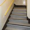
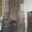
DP 222994
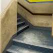
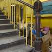
General view of main stair.
Records of the Royal Commission on the Ancient and Historical Monuments of Scotland (RCAHMS), Edinbu
3/9/2015
© Crown Copyright: HES

DP 222998
General view of double classroom at North on first floor.
Records of the Royal Commission on the Ancient and Historical Monuments of Scotland (RCAHMS), Edinbu
3/9/2015
© Crown Copyright: HES

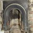
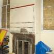
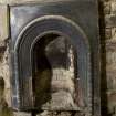
DP 223004
Detail of fireplace in staffroom.
Records of the Royal Commission on the Ancient and Historical Monuments of Scotland (RCAHMS), Edinbu
3/9/2015
© Crown Copyright: HES

DP 223005
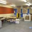
General view of classroom on second floor in 1950's extension
Records of the Royal Commission on the Ancient and Historical Monuments of Scotland (RCAHMS), Edinbu
3/9/2015
© Crown Copyright: HES

DP 223013
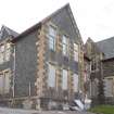
General view of main building from North West.
Records of the Royal Commission on the Ancient and Historical Monuments of Scotland (RCAHMS), Edinbu
3/9/2015
© Crown Copyright: HES

DP 223028
General view from South West showing play shelter.
Records of the Royal Commission on the Ancient and Historical Monuments of Scotland (RCAHMS), Edinbu
3/9/2015
© Crown Copyright: HES

DP 222992
General view of ground floor classroom at West.
Records of the Royal Commission on the Ancient and Historical Monuments of Scotland (RCAHMS), Edinbu
3/9/2015
© Crown Copyright: HES

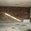
DP 222993
Detail of fireplace opening in Ground floor classroom at West.
Records of the Royal Commission on the Ancient and Historical Monuments of Scotland (RCAHMS), Edinbu
3/9/2015
© Crown Copyright: HES

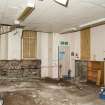
DP 223002
General view of staff room.
Records of the Royal Commission on the Ancient and Historical Monuments of Scotland (RCAHMS), Edinbu
3/9/2015
© Crown Copyright: HES

DP 223008
General view of secondary staircase at South.
Records of the Royal Commission on the Ancient and Historical Monuments of Scotland (RCAHMS), Edinbu
3/9/2015
© Crown Copyright: HES

DP 223021
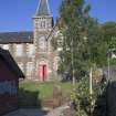
General view from South.
Records of the Royal Commission on the Ancient and Historical Monuments of Scotland (RCAHMS), Edinbu
3/9/2015
© Crown Copyright: HES

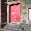
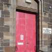
DP 223023
Detail of main entrance door at North end.
Records of the Royal Commission on the Ancient and Historical Monuments of Scotland (RCAHMS), Edinbu
3/9/2015
© Crown Copyright: HES

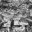
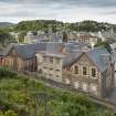
SC 1269198
Oban, general view, showing Royal Hotel, Argyll Square and McCaig's Tower. Oblique aerial photograph taken facing north-east.
Records of Aerofilms Ltd, aerial photographers, Bristol, England
25/4/1949
© Copyright: HES (Aerofilms Collection)

DP 222987
General view of former hall.
Records of the Royal Commission on the Ancient and Historical Monuments of Scotland (RCAHMS), Edinbu
3/9/2015
© Crown Copyright: HES

DP 222990
General view of main North -South corridor.
Records of the Royal Commission on the Ancient and Historical Monuments of Scotland (RCAHMS), Edinbu
3/9/2015
© Crown Copyright: HES

DP 223003
Detail of fireplace in staffroom.
Records of the Royal Commission on the Ancient and Historical Monuments of Scotland (RCAHMS), Edinbu
3/9/2015
© Crown Copyright: HES

DP 222985
General view from North East.
Records of the Royal Commission on the Ancient and Historical Monuments of Scotland (RCAHMS), Edinbu
3/9/2015
© Crown Copyright: HES

DP 222988
Detail of former hall fireplace.
Records of the Royal Commission on the Ancient and Historical Monuments of Scotland (RCAHMS), Edinbu
3/9/2015
© Crown Copyright: HES

DP 223000
General view of landing at top of main stair.
Records of the Royal Commission on the Ancient and Historical Monuments of Scotland (RCAHMS), Edinbu
3/9/2015
© Crown Copyright: HES

DP 223007
General view of central stair.
Records of the Royal Commission on the Ancient and Historical Monuments of Scotland (RCAHMS), Edinbu
3/9/2015
© Crown Copyright: HES

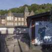
DP 223009
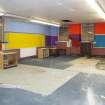
General view of mural in play shelter.
Records of the Royal Commission on the Ancient and Historical Monuments of Scotland (RCAHMS), Edinbu
3/9/2015
© Crown Copyright: HES

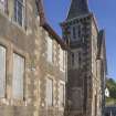
DP 223018
General view from West.
Records of the Royal Commission on the Ancient and Historical Monuments of Scotland (RCAHMS), Edinbu
3/9/2015
© Crown Copyright: HES

DP 222984
General View from East
Records of the Royal Commission on the Ancient and Historical Monuments of Scotland (RCAHMS), Edinbu
3/9/2015
© Crown Copyright: HES

DP 222997
General view of double classroom at South on first floor.
Records of the Royal Commission on the Ancient and Historical Monuments of Scotland (RCAHMS), Edinbu
3/9/2015
© Crown Copyright: HES

DP 223006
General view of classroom on second floor in 1950's extension
Records of the Royal Commission on the Ancient and Historical Monuments of Scotland (RCAHMS), Edinbu
3/9/2015
© Crown Copyright: HES

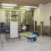
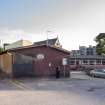
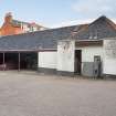
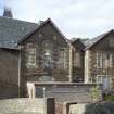
DP 223016
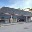
General view of ancillary buildings.
Records of the Royal Commission on the Ancient and Historical Monuments of Scotland (RCAHMS), Edinbu
3/9/2015
© Crown Copyright: HES

DP 223017
General view from West.
Records of the Royal Commission on the Ancient and Historical Monuments of Scotland (RCAHMS), Edinbu
3/9/2015
© Crown Copyright: HES

DP 223026
General view from west showing tower and railings.
Records of the Royal Commission on the Ancient and Historical Monuments of Scotland (RCAHMS), Edinbu
3/9/2015
© Crown Copyright: HES

DP 222999
General view of double classroom at North on first floor.
Records of the Royal Commission on the Ancient and Historical Monuments of Scotland (RCAHMS), Edinbu
3/9/2015
© Crown Copyright: HES

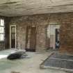
DP 223001
General view of first floor classroom at West end.
Records of the Royal Commission on the Ancient and Historical Monuments of Scotland (RCAHMS), Edinbu
3/9/2015
© Crown Copyright: HES

DP 223011
General view of main building from North West.
Records of the Royal Commission on the Ancient and Historical Monuments of Scotland (RCAHMS), Edinbu
3/9/2015
© Crown Copyright: HES

DP 223019
General view from North West.
Records of the Royal Commission on the Ancient and Historical Monuments of Scotland (RCAHMS), Edinbu
3/9/2015
© Crown Copyright: HES

DP 223022
Detail of main entrance door at South end.
Records of the Royal Commission on the Ancient and Historical Monuments of Scotland (RCAHMS), Edinbu
3/9/2015
© Crown Copyright: HES

DP 222986
General view of play shelter from East.
Records of the Royal Commission on the Ancient and Historical Monuments of Scotland (RCAHMS), Edinbu
3/9/2015
© Crown Copyright: HES

DP 222991
General view of ground floor classroom at North end in 1955 extension.
Records of the Royal Commission on the Ancient and Historical Monuments of Scotland (RCAHMS), Edinbu
3/9/2015
© Crown Copyright: HES

DP 222995
General view of main stair showing newel post.
Records of the Royal Commission on the Ancient and Historical Monuments of Scotland (RCAHMS), Edinbu
3/9/2015
© Crown Copyright: HES

DP 223012
General view of main building from North West showing railings..
Records of the Royal Commission on the Ancient and Historical Monuments of Scotland (RCAHMS), Edinbu
3/9/2015
© Crown Copyright: HES

DP 223014
General view from West.
Records of the Royal Commission on the Ancient and Historical Monuments of Scotland (RCAHMS), Edinbu
3/9/2015
© Crown Copyright: HES

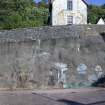
DP 223015
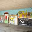
General view of bundary wall with murals.
Records of the Royal Commission on the Ancient and Historical Monuments of Scotland (RCAHMS), Edinbu
3/9/2015
© Crown Copyright: HES

DP 223020
General view from South.
Records of the Royal Commission on the Ancient and Historical Monuments of Scotland (RCAHMS), Edinbu
3/9/2015
© Crown Copyright: HES

DP 223025
General view from South West showing railings.
Records of the Royal Commission on the Ancient and Historical Monuments of Scotland (RCAHMS), Edinbu
3/9/2015
© Crown Copyright: HES

DP 223027
General view from West showing ancillary buildings.
Records of the Royal Commission on the Ancient and Historical Monuments of Scotland (RCAHMS), Edinbu
3/9/2015
© Crown Copyright: HES


- Council Argyll And Bute
- Parish Kilmore And Kilbride
- Former Region Strathclyde
- Former District Argyll And Bute
- Former County Argyll

