
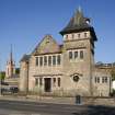
Bute, Rothesay, High Street, Former United Free Church


Boundary Wall (20th Century), Church (20th Century), Warehouse (20th Century)
Site Name Bute, Rothesay, High Street, Former United Free Church
Classification Boundary Wall (20th Century), Church (20th Century), Warehouse (20th Century)
Canmore ID 233302
Site Number NS06SE 228
NGR NS 08849 64462
Datum OSGB36 - NGR
Permalink http://canmore.org.uk/site/233302


- Council Argyll And Bute
- Parish Rothesay
- Former Region Strathclyde
- Former District Argyll And Bute
- Former County Buteshire
Asymmetrical 2-storey with attic, 2-bay former United Free church with projecting Flemish-style tower to right; advanced gabled bay at centre; later single storey additions to S and E. Coursed, slightly bull-faced sandstone; polished sandstone dressings. Raised base course; corniced openings at ground and 1st floors; skewed gables; corniced eaves; overhanging bracketed eaves to square-plan tower. Raised ashlar quoins; long and short surrounds to openings; chamfered cills at ground to E; projecting cills to N; stone mullions; stained glazing. Harl-pointed random rubble sandstone to sides and rear; polished dressings; harled later additions.
No longer in ecclesiastical use. An unusual building with some interesting features - note the stained glazing, the stone-mullioned glazing rows and the bell-cast square-plan tower. The original plans show an interesting interior with hammerbeam roof, extensive timber panelling and a timber pulpit.
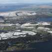
Rothesay is one of Scotland's premier seaside resorts, developed primarily during the second half of the 19th and early 20th centuries, and incorporates an earlier medieval settlement. The town retains a wide range of buildings characteristic of its development as a high status 19th century holiday resort, including a range of fine villas, a Victorian pier and promenade.
The history and development of Rothesay is defined by two major phases. The development of the medieval town, centred on Rothesay Castle, and the later 19th and early 20th century development of the town as a seaside resort. Buildings from this later development, reflect the wealth of the town during its heyday as a tourist destination, and include a range of domestic and commercial architecture of a scale sometimes found in larger burghs. Both the 19th and early 20th century growth of the town, with a particular flourish during the inter-war period, included areas of reclaimed foreshore, particularly along the coast to the east of the town and around the pier and pleasure gardens.
(List description revised as part of Rothesay listing review 2010-11). (Historic Scotland)
Characterisation (28 July 2010)
This site falls within The Bush Area of Townscape Character which was defined as part of the Rothesay Urban Survey Project, 2010. The text below relates to the whole area.
Historical Development and Topography
This area to the east side of the original High Street is mostly an area of 20th and 21st century development on the outskirts of the town. Early origins of the area follow the original High Street, which consists mostly of 19th century tenements with many later redevelopments.
Plot sizes in this area range from smaller communal plots in the densely packed northern portion near the boundary with the Town Centre Area of Townscape Character, to larger shared plots in the more dispersed planned crescent and avenue of local authority housing on the southern outskirts of town.
The main reasons for the form of this area are partly topography, with 20th century developments spreading up the eastern side of the valley, and partly the route of the historic High Street and associated plot layout.
The Bush can largely be said to be mid- to late 20th century in character, with several redevelopments of plots on the east side of the High Street at Nos 135-7 on the northern corner with Ministers Brae built in the 1950s, and Nos 81-133 opposite Russell Street dating from the 1970s. The southern portion has seen a great deal of infilling, with the timber-clad local authority housing built on the estate of Bush House in the 1940s.
The most recent redevelopments in the area have been carried out by the local housing association, Fyne Homes. A’Chrannaig, completed in 2005, sits on the hill above Foley Court and the High Street, and was designed by architect Gokay Deveci. This distinctive circular block of flats was built on the site of the former Foley House, an 18th century villa which was damaged by fire in 1995, and was shortlisted for the RIAS Andrew Doolan Award for Architecture, Best Building in Scotland in 2005. Nos 1-19 Mansefield Place which occupies a site on the corner of the High Street and Minister’s Brae, was completed in 2009 and provides a terrace of red brick and slate-hung townhouse-style accommodation.
Present Character
The character of The Bush is mostly residential in nature, and mainly 20th century local authority and housing association properties, particularly in the southern portion. Whilst the eastern boundary of the area is the High Street, the original main road into the burgh, very little else remains in this area to represent these early beginnings of the town of Rothesay.
The earliest building in the area is the former Drill Hall, built sometime between 1865 and 1896, situated just off the High Street behind the United Free Church on the boundary with the Town Centre Area of Townscape Character and now in use as a furniture showroom. The United Free Church was built in 1911 and designed by Duncan Dewar. This is no longer in use, having last been used as a furniture and carpet warehouse store. The church has square-plan Flemish-style bell-tower with a bell-cast roof which has a shallower pitch to the bottom portion, giving the roof a bell-like shape.
Two substantial villas with associated estates originally stood within the boundaries of The Bush: Foley House and Bush House. Both dated from the 18th century and are no longer visible in the landscape today. Bush House and its lands were redeveloped in the 1940s by the local authority to build the timber-clad housing in the southern portion of the area. Foley House was seriously damaged by fire in 1995, demolished, and the circular block of flats A’Chrannaig erected on the site in 2005 by Fyne Homes to designs by Gokay Deveci. Further redevelopment in the area by Fyne Homes has taken place on the High Street at its junction with the southern corner of Minister’s Brae. This red brick development has provided nineteen townhouse-style properties on land previously occupied by tenements. Such redevelopment is typical of the ‘thinning out’ of the urban population – where four units of development were encompassed within one tenement, there is now one unit composed of a three-storeyed townhouse.
On the whole, units of development and plot sizes remain smaller nearer the Town Centre Area of Townscape Character, with larger units in the local authority developments to the south.
While the vast majority of this area is residential in nature, there are supporting functions in the form of the town’s fire station, designed by W R Tocher and built in 1965 on the southern edge of the area, the United Free Church which has subsequently been put to new uses, and small-scale industry works near the boundary with Town Centre Area of Townscape Character and Industrial Rothesay Area of Townscape Character.
Information from RCAHMS (LK), 28th July 2010

