
Pricing Change
New pricing for orders of material from this site will come into place shortly. Charges for supply of digital images, digitisation on demand, prints and licensing will be altered.
Craw Howe


Mound(S) (Period Unassigned)
Site Name Craw Howe
Classification Mound(S) (Period Unassigned)
Canmore ID 2333
Site Number HY40NE 19
NGR HY 4908 0696
Datum OSGB36 - NGR
Permalink http://canmore.org.uk/site/2333


- Council Orkney Islands
- Parish St Andrews And Deerness
- Former Region Orkney Islands Area
- Former District Orkney
- Former County Orkney
HY40NE 19 4908 0696.
At HY 4908 0696 is a mound known as Craw Howe which may be a tumulus. The top has been dug into, but no record could be found of any finds.
Surveyed at 1:2500.
Visited by OS(RD) 16 April 1964
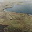
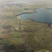
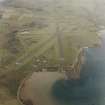
On the hill SE of the airport, at 60m OD, there is an artificial-looking mound so covered in thick peat that its proper dimensions and composition cannot be reliably be ascertained. To the E of it are two slighter but generally similar mounds.
RCAHMS 1987, visited April 1979
Field Visit (22 October 1993)
This site was visited during the Orkney Barrows Project but was not recorded in detail. It was noted that the mounds are still very well defined. One of the mounds measured 12.0m by 13.0m and 1.1m in height. They are prominent to the NE and NW for 500-1km.
Information from the Orkney Barrows Project (JD), 1993
Orkney Smr Note
Possible tumulus. Top dug into but no record of finds. Divorced survey at 1:2500.
OS visit Apr 1964.
As described. There are 2 other, slighter but similar mounds to E, but no indication whether artificial or not.
Information from Orkney SMR (RGL) Apr 1979.

