
Achacha


Kerb Cairn (Bronze Age)
Site Name Achacha
Classification Kerb Cairn (Bronze Age)
Alternative Name(s) Loch Creran
Canmore ID 23329
Site Number NM94SW 8
NGR NM 9436 4076
Datum OSGB36 - NGR
Permalink http://canmore.org.uk/site/23329


- Council Argyll And Bute
- Parish Ardchattan And Muckairn (Argyll And Bute)
- Former Region Strathclyde
- Former District Argyll And Bute
- Former County Argyll
NM94SW 8 9436 4076.
(NM 9436 4076) Cairn (NR) (rems of)
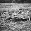
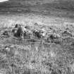
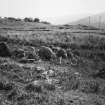
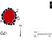
Situated in an area of upland pasture between Cnoc Reamhar and the Allt Garraich burn are the remains of a cairn. It is oval in shape, measuring 4.6 metres N-S and 4 metres transversely. It is kerbed by a series of granite boulders measuring up to 0.7 metres in height, of which 15 remain 'in situ', the others lying dislodged nearby. The cairn material is lower than the kerb, attaining a height of only 0.3 metres above the surrounding ground, but is unlikely that it was ever much higher than this.
RCAHMS 1975.
As described.
Surveyed at 1:10 000 scale.
Visited by OS (WDJ) 28 April 1970.
Field Visit (May 1970)
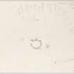
NM 943 407. A cairn and a standing stone (NM94SW 9) are situated in an area of upland pasture between Cnoc Reamhar and the Allt Garraich burn at a height of about 50 m OD. The cairn (plan, Fig. 15) is oval on plan and measures 4.6 m from N to S by 4'0 m transversely. It is kerbed by a series of large boulders, mainly granite erratics measuring up to 0'7 m in height, fifteen of which remain in situ; others are lying dislodged nearby. The cairn material is rather lower than the kerb, standing to a height of only 0'3 m above the surrounding ground, and it seems unlikely that it was ever appreciably higher. This cairn belongs to a distinct class of monument, which is further discussed on p. 10.
RCAHMS 1975, visited May 1970.
Measured Survey (4 May 1971)
Surveyed at 4mm:1ft. Redrawn in ink and published at 1:250 (RCAHMS 1975, fig. 15).

